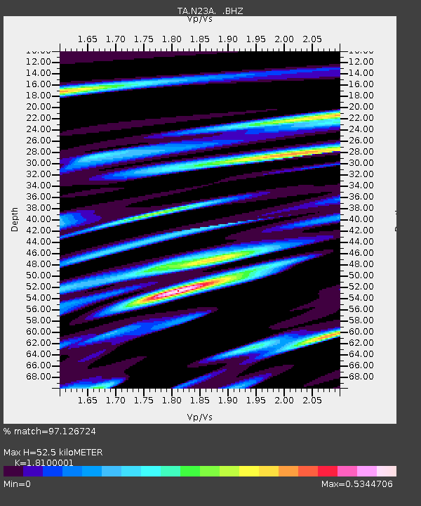
N23A Red Feather Lakes, CO, USA - Earthquake Result Viewer

Earthquake location: Off East Coast Of Honshu, Japan
Earthquake latitude/longitude: 36.8/143.8
Earthquake time(UTC): 2011/08/17 (229) 11:44:08 GMT
Earthquake Depth: 9.0 km
Earthquake Magnitude: 6.1 MB, 5.8 MS, 6.2 MW, 6.1 MW
Earthquake Catalog/Contributor: WHDF/NEIC
Network: TA USArray Transportable Network (new EarthScope stations)
Station: N23A Red Feather Lakes, CO, USA
Lat/Lon: 40.89 N/105.94 W
Elevation: 2458 m
Distance: 79.8 deg
Az: 46.265 deg
Baz: 310.059 deg
Ray Param: 0.048734855
Estimated Moho Depth: 52.5 km
Estimated Crust Vp/Vs: 1.81
Assumed Crust Vp: 6.306 km/s
Estimated Crust Vs: 3.484 km/s
Estimated Crust Poisson's Ratio: 0.28
Radial Match: 97.126724 %
Radial Bump: 400
Transverse Match: 90.49983 %
Transverse Bump: 400
SOD ConfigId: 410809
Insert Time: 2012-01-06 06:44:45.738 +0000
GWidth: 2.5
Max Bumps: 400
Tol: 0.001

Signal To Noise

ChannelStoNSTALTA
TA:N23A: :BHZ:20110817T11:55:45.325017Z33.7318731.4922638E-64.423898E-8
TA:N23A: :BHN:20110817T11:55:45.325017Z5.744814.8750536E-78.486014E-8
TA:N23A: :BHE:20110817T11:55:45.325017Z6.90048653.7780026E-75.4749805E-8
Arrivals
Ps6.9 SECOND
PpPs23 SECOND
PsPs/PpSs30 SECOND