You are here: Home > Network List > TA - USArray Transportable Network (new EarthScope stations) Stations List
> Station H25A Fruitdale, SD, USA > Earthquake Result Viewer
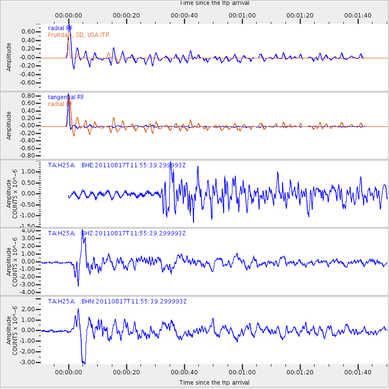
H25A Fruitdale, SD, USA - Earthquake Result Viewer
*The percent match for this event was below the threshold and hence no stack was calculated.
| Earthquake location: |
Off East Coast Of Honshu, Japan |
| Earthquake latitude/longitude: |
36.8/143.8 |
| Earthquake time(UTC): |
2011/08/17 (229) 11:44:08 GMT |
| Earthquake Depth: |
9.0 km |
| Earthquake Magnitude: |
6.1 MB, 5.8 MS, 6.2 MW, 6.1 MW |
| Earthquake Catalog/Contributor: |
WHDF/NEIC |
|
| Network: |
TA USArray Transportable Network (new EarthScope stations) |
| Station: |
H25A Fruitdale, SD, USA |
| Lat/Lon: |
44.62 N/103.60 W |
| Elevation: |
942 m |
|
| Distance: |
78.7 deg |
| Az: |
42.24 deg |
| Baz: |
310.894 deg |
| Ray Param: |
$rayparam |
*The percent match for this event was below the threshold and hence was not used in the summary stack. |
|
| Radial Match: |
91.29727 % |
| Radial Bump: |
400 |
| Transverse Match: |
99.239525 % |
| Transverse Bump: |
135 |
| SOD ConfigId: |
410809 |
| Insert Time: |
2012-01-06 06:45:40.428 +0000 |
| GWidth: |
2.5 |
| Max Bumps: |
400 |
| Tol: |
0.001 |
|
Signal To Noise
| Channel | StoN | STA | LTA |
| TA:H25A: :BHZ:20110817T11:55:39.299993Z | 33.228695 | 1.4745781E-6 | 4.4376645E-8 |
| TA:H25A: :BHN:20110817T11:55:39.299993Z | 18.679888 | 1.0894719E-6 | 5.8323252E-8 |
| TA:H25A: :BHE:20110817T11:55:39.299993Z | 4.3487144 | 4.237377E-7 | 9.743977E-8 |
| Arrivals |
| Ps | |
| PpPs | |
| PsPs/PpSs | |


