You are here: Home > Network List > TA - USArray Transportable Network (new EarthScope stations) Stations List
> Station O32A Brockman Farm, Red Cloud, NE, USA > Earthquake Result Viewer
O32A Brockman Farm, Red Cloud, NE, USA - Earthquake Result Viewer
| Earthquake location: |
Off East Coast Of Honshu, Japan |
| Earthquake latitude/longitude: |
36.8/143.8 |
| Earthquake time(UTC): |
2011/08/17 (229) 11:44:08 GMT |
| Earthquake Depth: |
9.0 km |
| Earthquake Magnitude: |
6.1 MB, 5.8 MS, 6.2 MW, 6.1 MW |
| Earthquake Catalog/Contributor: |
WHDF/NEIC |
|
| Network: |
TA USArray Transportable Network (new EarthScope stations) |
| Station: |
O32A Brockman Farm, Red Cloud, NE, USA |
| Lat/Lon: |
40.26 N/98.28 W |
| Elevation: |
579 m |
|
| Distance: |
84.5 deg |
| Az: |
42.771 deg |
| Baz: |
314.554 deg |
| Ray Param: |
0.04542964 |
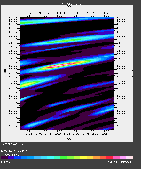
| Estimated Moho Depth: |
35.5 km |
| Estimated Crust Vp/Vs: |
1.82 |
| Assumed Crust Vp: |
6.53 km/s |
| Estimated Crust Vs: |
3.593 km/s |
| Estimated Crust Poisson's Ratio: |
0.28 |
|
| Radial Match: |
92.698166 % |
| Radial Bump: |
400 |
| Transverse Match: |
79.962 % |
| Transverse Bump: |
400 |
| SOD ConfigId: |
410809 |
| Insert Time: |
2012-01-06 06:47:19.354 +0000 |
| GWidth: |
2.5 |
| Max Bumps: |
400 |
| Tol: |
0.001 |
|

Signal To Noise
| Channel | StoN | STA | LTA |
| TA:O32A: :BHZ:20110817T11:56:10.09998Z | 21.009644 | 2.1518474E-6 | 1.024219E-7 |
| TA:O32A: :BHN:20110817T11:56:10.09998Z | 4.9003534 | 6.6802346E-7 | 1.3632149E-7 |
| TA:O32A: :BHE:20110817T11:56:10.09998Z | 5.6070633 | 7.3224084E-7 | 1.3059257E-7 |
| Arrivals |
| Ps | 4.6 SECOND |
| PpPs | 15 SECOND |
| PsPs/PpSs | 19 SECOND |


