You are here: Home > Network List > G - GEOSCOPE Stations List
> Station DRV Dumont d'Urville, Terre Adelie (Antartica) > Earthquake Result Viewer
DRV Dumont d'Urville, Terre Adelie (Antartica) - Earthquake Result Viewer
| Earthquake location: |
Mindanao, Philippines |
| Earthquake latitude/longitude: |
8.1/126.3 |
| Earthquake time(UTC): |
1997/03/11 (070) 19:21:23 GMT |
| Earthquake Depth: |
88 km |
| Earthquake Magnitude: |
5.7 MB |
| Earthquake Catalog/Contributor: |
WHDF/NEIC |
|
| Network: |
G GEOSCOPE |
| Station: |
DRV Dumont d'Urville, Terre Adelie (Antartica) |
| Lat/Lon: |
66.67 S/140.01 E |
| Elevation: |
40 m |
|
| Distance: |
75.3 deg |
| Az: |
174.416 deg |
| Baz: |
346.004 deg |
| Ray Param: |
0.05158248 |
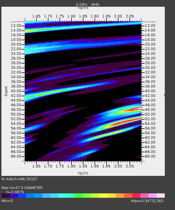
| Estimated Moho Depth: |
47.0 km |
| Estimated Crust Vp/Vs: |
2.10 |
| Assumed Crust Vp: |
6.39 km/s |
| Estimated Crust Vs: |
3.046 km/s |
| Estimated Crust Poisson's Ratio: |
0.35 |
|
| Radial Match: |
96.30327 % |
| Radial Bump: |
400 |
| Transverse Match: |
80.3345 % |
| Transverse Bump: |
400 |
| SOD ConfigId: |
4480 |
| Insert Time: |
2010-02-26 22:05:12.038 +0000 |
| GWidth: |
2.5 |
| Max Bumps: |
400 |
| Tol: |
0.001 |
|
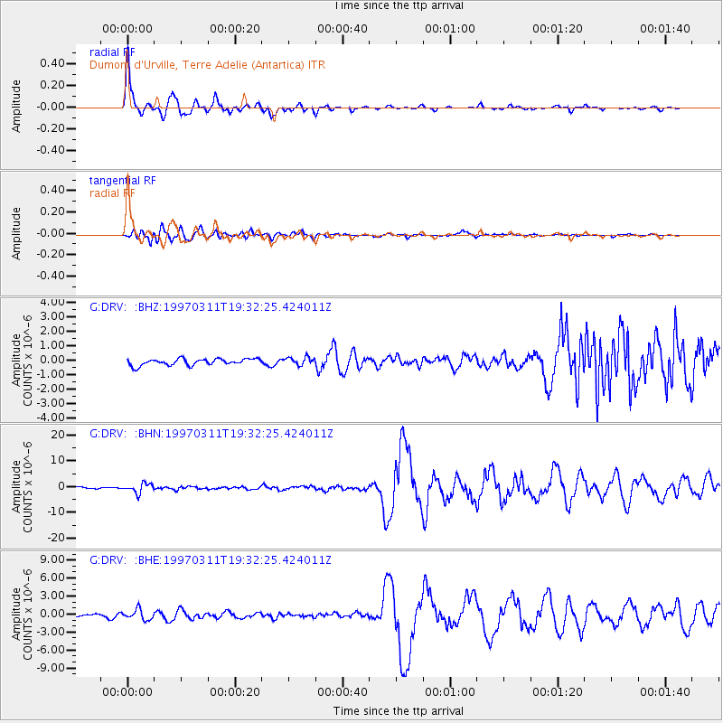
Signal To Noise
| Channel | StoN | STA | LTA |
| G:DRV: :BHN:19970311T19:32:25.424011Z | 4.5749087 | 1.8008976E-6 | 3.9364667E-7 |
| G:DRV: :BHE:19970311T19:32:25.424011Z | 2.5141184 | 8.694147E-7 | 3.4581296E-7 |
| G:DRV: :BHZ:19970311T19:32:25.424011Z | 1.2338058 | 2.8054603E-7 | 2.2738267E-7 |
| Arrivals |
| Ps | 8.3 SECOND |
| PpPs | 22 SECOND |
| PsPs/PpSs | 30 SECOND |


