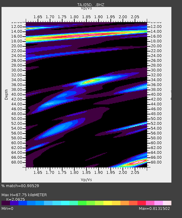
I05D Terrebonne, OR, USA - Earthquake Result Viewer
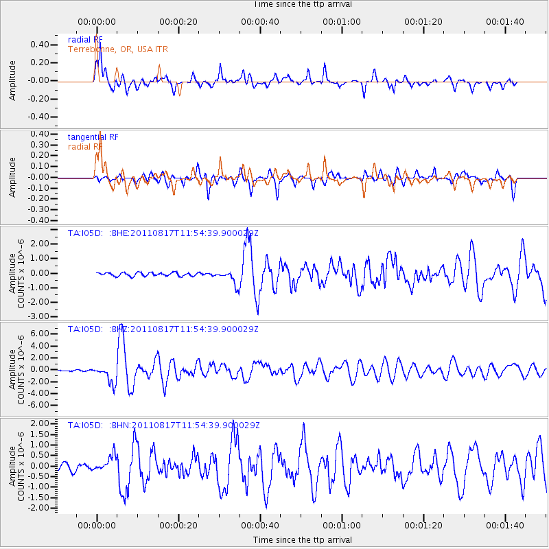
Earthquake location: Off East Coast Of Honshu, Japan
Earthquake latitude/longitude: 36.8/143.8
Earthquake time(UTC): 2011/08/17 (229) 11:44:08 GMT
Earthquake Depth: 9.0 km
Earthquake Magnitude: 6.1 MB, 5.8 MS, 6.2 MW, 6.1 MW
Earthquake Catalog/Contributor: WHDF/NEIC
Network: TA USArray Transportable Network (new EarthScope stations)
Station: I05D Terrebonne, OR, USA
Lat/Lon: 44.34 N/121.34 W
Elevation: 1546 m
Distance: 68.5 deg
Az: 50.196 deg
Baz: 300.713 deg
Ray Param: 0.056243245
Estimated Moho Depth: 67.75 km
Estimated Crust Vp/Vs: 2.06
Assumed Crust Vp: 6.597 km/s
Estimated Crust Vs: 3.199 km/s
Estimated Crust Poisson's Ratio: 0.35
Radial Match: 80.98529 %
Radial Bump: 400
Transverse Match: 77.64774 %
Transverse Bump: 400
SOD ConfigId: 410809
Insert Time: 2012-01-06 06:49:49.049 +0000
GWidth: 2.5
Max Bumps: 400
Tol: 0.001

Signal To Noise

ChannelStoNSTALTA
TA:I05D: :BHZ:20110817T11:54:39.900029Z11.3754551.5454265E-61.3585624E-7
TA:I05D: :BHN:20110817T11:54:39.900029Z2.57870583.9768378E-71.5421837E-7
TA:I05D: :BHE:20110817T11:54:39.900029Z4.4248985.163845E-71.1669974E-7
Arrivals
Ps11 SECOND
PpPs30 SECOND
PsPs/PpSs42 SECOND