You are here: Home > Network List > TA - USArray Transportable Network (new EarthScope stations) Stations List
> Station R32A Long Quarter, Great Bend, KS, USA > Earthquake Result Viewer
R32A Long Quarter, Great Bend, KS, USA - Earthquake Result Viewer
| Earthquake location: |
Off East Coast Of Honshu, Japan |
| Earthquake latitude/longitude: |
36.8/143.8 |
| Earthquake time(UTC): |
2011/08/17 (229) 11:44:08 GMT |
| Earthquake Depth: |
9.0 km |
| Earthquake Magnitude: |
6.1 MB, 5.8 MS, 6.2 MW, 6.1 MW |
| Earthquake Catalog/Contributor: |
WHDF/NEIC |
|
| Network: |
TA USArray Transportable Network (new EarthScope stations) |
| Station: |
R32A Long Quarter, Great Bend, KS, USA |
| Lat/Lon: |
38.42 N/98.71 W |
| Elevation: |
573 m |
|
| Distance: |
85.6 deg |
| Az: |
44.323 deg |
| Baz: |
314.414 deg |
| Ray Param: |
0.044677824 |
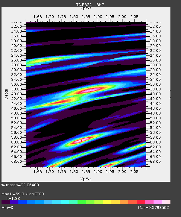
| Estimated Moho Depth: |
59.0 km |
| Estimated Crust Vp/Vs: |
1.83 |
| Assumed Crust Vp: |
6.483 km/s |
| Estimated Crust Vs: |
3.542 km/s |
| Estimated Crust Poisson's Ratio: |
0.29 |
|
| Radial Match: |
93.86409 % |
| Radial Bump: |
400 |
| Transverse Match: |
78.49206 % |
| Transverse Bump: |
400 |
| SOD ConfigId: |
410809 |
| Insert Time: |
2012-01-06 06:50:42.643 +0000 |
| GWidth: |
2.5 |
| Max Bumps: |
400 |
| Tol: |
0.001 |
|
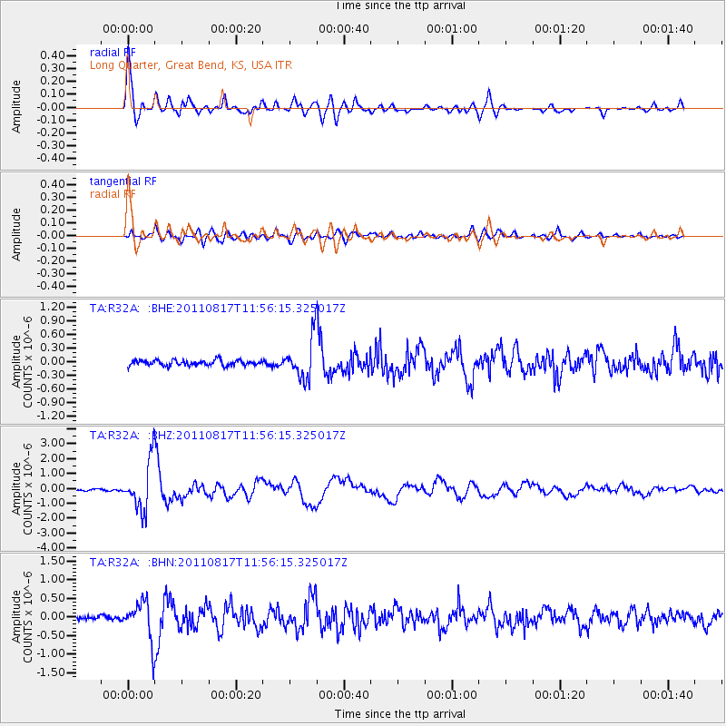
Signal To Noise
| Channel | StoN | STA | LTA |
| TA:R32A: :BHZ:20110817T11:56:15.325017Z | 20.018179 | 1.6676272E-6 | 8.330564E-8 |
| TA:R32A: :BHN:20110817T11:56:15.325017Z | 6.9270854 | 5.242524E-7 | 7.5681534E-8 |
| TA:R32A: :BHE:20110817T11:56:15.325017Z | 7.631551 | 4.660019E-7 | 6.106254E-8 |
| Arrivals |
| Ps | 7.7 SECOND |
| PpPs | 25 SECOND |
| PsPs/PpSs | 33 SECOND |


