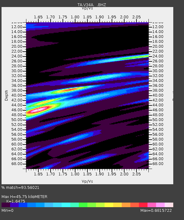
V34A Guthrie, OK, USA - Earthquake Result Viewer
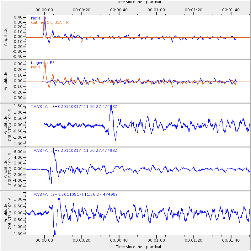
Earthquake location: Off East Coast Of Honshu, Japan
Earthquake latitude/longitude: 36.8/143.8
Earthquake time(UTC): 2011/08/17 (229) 11:44:08 GMT
Earthquake Depth: 9.0 km
Earthquake Magnitude: 6.1 MB, 5.8 MS, 6.2 MW, 6.1 MW
Earthquake Catalog/Contributor: WHDF/NEIC
Network: TA USArray Transportable Network (new EarthScope stations)
Station: V34A Guthrie, OK, USA
Lat/Lon: 35.83 N/97.52 W
Elevation: 329 m
Distance: 88.1 deg
Az: 45.485 deg
Baz: 315.196 deg
Ray Param: 0.042870622
Estimated Moho Depth: 45.75 km
Estimated Crust Vp/Vs: 1.65
Assumed Crust Vp: 6.426 km/s
Estimated Crust Vs: 3.901 km/s
Estimated Crust Poisson's Ratio: 0.21
Radial Match: 93.56021 %
Radial Bump: 400
Transverse Match: 85.293724 %
Transverse Bump: 400
SOD ConfigId: 410809
Insert Time: 2012-01-06 06:50:55.740 +0000
GWidth: 2.5
Max Bumps: 400
Tol: 0.001

Signal To Noise

ChannelStoNSTALTA
TA:V34A: :BHZ:20110817T11:56:27.47498Z24.5769251.7579883E-67.153003E-8
TA:V34A: :BHN:20110817T11:56:27.47498Z3.73761583.049096E-78.157864E-8
TA:V34A: :BHE:20110817T11:56:27.47498Z3.46946743.1038837E-78.946283E-8
Arrivals
Ps4.7 SECOND
PpPs18 SECOND
PsPs/PpSs23 SECOND