You are here: Home > Network List > TA - USArray Transportable Network (new EarthScope stations) Stations List
> Station 237A Washetta, Montalba, TX, USA > Earthquake Result Viewer
237A Washetta, Montalba, TX, USA - Earthquake Result Viewer
| Earthquake location: |
Off East Coast Of Honshu, Japan |
| Earthquake latitude/longitude: |
36.8/143.8 |
| Earthquake time(UTC): |
2011/08/17 (229) 11:44:08 GMT |
| Earthquake Depth: |
9.0 km |
| Earthquake Magnitude: |
6.1 MB, 5.8 MS, 6.2 MW, 6.1 MW |
| Earthquake Catalog/Contributor: |
WHDF/NEIC |
|
| Network: |
TA USArray Transportable Network (new EarthScope stations) |
| Station: |
237A Washetta, Montalba, TX, USA |
| Lat/Lon: |
32.00 N/95.81 W |
| Elevation: |
126 m |
|
| Distance: |
91.8 deg |
| Az: |
47.139 deg |
| Baz: |
316.148 deg |
| Ray Param: |
0.041557256 |
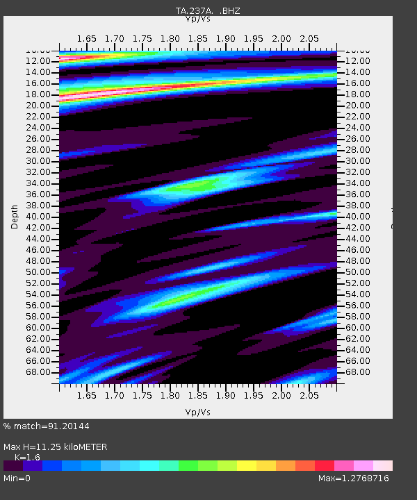
| Estimated Moho Depth: |
11.25 km |
| Estimated Crust Vp/Vs: |
1.60 |
| Assumed Crust Vp: |
6.245 km/s |
| Estimated Crust Vs: |
3.903 km/s |
| Estimated Crust Poisson's Ratio: |
0.18 |
|
| Radial Match: |
91.20144 % |
| Radial Bump: |
400 |
| Transverse Match: |
69.56467 % |
| Transverse Bump: |
400 |
| SOD ConfigId: |
410809 |
| Insert Time: |
2012-01-06 06:55:24.837 +0000 |
| GWidth: |
2.5 |
| Max Bumps: |
400 |
| Tol: |
0.001 |
|

Signal To Noise
| Channel | StoN | STA | LTA |
| TA:237A: :BHZ:20110817T11:56:44.825017Z | 7.1883597 | 8.89278E-7 | 1.2371085E-7 |
| TA:237A: :BHN:20110817T11:56:44.825017Z | 1.3732746 | 2.4034114E-7 | 1.7501318E-7 |
| TA:237A: :BHE:20110817T11:56:44.825017Z | 0.9741315 | 1.5758947E-7 | 1.6177432E-7 |
| Arrivals |
| Ps | 1.1 SECOND |
| PpPs | 4.6 SECOND |
| PsPs/PpSs | 5.7 SECOND |


