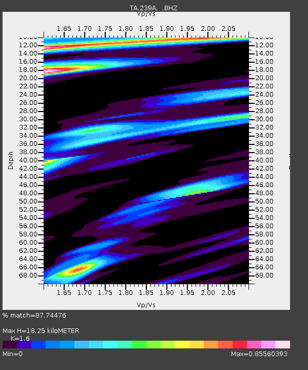
239A Gary, TX, USA - Earthquake Result Viewer
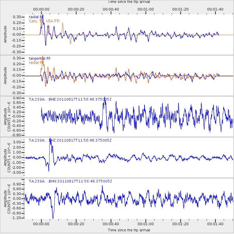
Earthquake location: Off East Coast Of Honshu, Japan
Earthquake latitude/longitude: 36.8/143.8
Earthquake time(UTC): 2011/08/17 (229) 11:44:08 GMT
Earthquake Depth: 9.0 km
Earthquake Magnitude: 6.1 MB, 5.8 MS, 6.2 MW, 6.1 MW
Earthquake Catalog/Contributor: WHDF/NEIC
Network: TA USArray Transportable Network (new EarthScope stations)
Station: 239A Gary, TX, USA
Lat/Lon: 32.02 N/94.47 W
Elevation: 100 m
Distance: 92.6 deg
Az: 46.303 deg
Baz: 316.885 deg
Ray Param: 0.04143544
Estimated Moho Depth: 18.25 km
Estimated Crust Vp/Vs: 1.60
Assumed Crust Vp: 6.245 km/s
Estimated Crust Vs: 3.903 km/s
Estimated Crust Poisson's Ratio: 0.18
Radial Match: 87.74476 %
Radial Bump: 400
Transverse Match: 82.2609 %
Transverse Bump: 400
SOD ConfigId: 410809
Insert Time: 2012-01-06 06:55:32.755 +0000
GWidth: 2.5
Max Bumps: 400
Tol: 0.001

Signal To Noise

ChannelStoNSTALTA
TA:239A: :BHZ:20110817T11:56:48.375005Z10.7183939.687112E-79.037839E-8
TA:239A: :BHN:20110817T11:56:48.375005Z1.44211911.9715613E-71.367128E-7
TA:239A: :BHE:20110817T11:56:48.375005Z1.60178332.302628E-71.4375402E-7
Arrivals
Ps1.8 SECOND
PpPs7.4 SECOND
PsPs/PpSs9.2 SECOND