You are here: Home > Network List > GS - US Geological Survey Networks Stations List
> Station DEC12 Boyd Road Surface Site > Earthquake Result Viewer
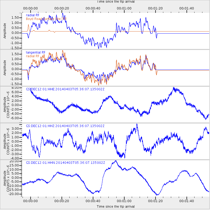
DEC12 Boyd Road Surface Site - Earthquake Result Viewer
*The percent match for this event was below the threshold and hence no stack was calculated.
| Earthquake location: |
Near Coast Of Northern Chile |
| Earthquake latitude/longitude: |
-20.8/-70.5 |
| Earthquake time(UTC): |
2014/04/03 (093) 05:26:16 GMT |
| Earthquake Depth: |
24 km |
| Earthquake Magnitude: |
6.2 MWP, 6.2 MWR, 6.3 MWW, 6.5 MWC |
| Earthquake Catalog/Contributor: |
NEIC PDE/NEIC COMCAT |
|
| Network: |
GS US Geological Survey Networks |
| Station: |
DEC12 Boyd Road Surface Site |
| Lat/Lon: |
39.91 N/88.91 W |
| Elevation: |
208 m |
|
| Distance: |
62.8 deg |
| Az: |
344.191 deg |
| Baz: |
160.649 deg |
| Ray Param: |
$rayparam |
*The percent match for this event was below the threshold and hence was not used in the summary stack. |
|
| Radial Match: |
59.162045 % |
| Radial Bump: |
400 |
| Transverse Match: |
57.405533 % |
| Transverse Bump: |
400 |
| SOD ConfigId: |
3390531 |
| Insert Time: |
2019-04-11 02:42:13.419 +0000 |
| GWidth: |
2.5 |
| Max Bumps: |
400 |
| Tol: |
0.001 |
|
Signal To Noise
| Channel | StoN | STA | LTA |
| GS:DEC12:01:HHZ:20140403T05:36:07.135002Z | 1.8297303 | 1.8291339E-6 | 9.996741E-7 |
| GS:DEC12:01:HHN:20140403T05:36:07.135002Z | 0.7664017 | 6.6640923E-6 | 8.6953E-6 |
| GS:DEC12:01:HHE:20140403T05:36:07.135002Z | 1.034565 | 2.5904094E-6 | 2.5038632E-6 |
| Arrivals |
| Ps | |
| PpPs | |
| PsPs/PpSs | |


