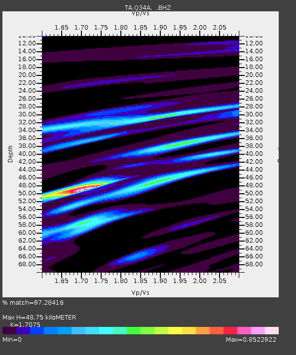
Q34A Chapman, KS, USA - Earthquake Result Viewer

Earthquake location: Off East Coast Of Honshu, Japan
Earthquake latitude/longitude: 36.8/143.8
Earthquake time(UTC): 2011/08/17 (229) 11:44:08 GMT
Earthquake Depth: 9.0 km
Earthquake Magnitude: 6.1 MB, 5.8 MS, 6.2 MW, 6.1 MW
Earthquake Catalog/Contributor: WHDF/NEIC
Network: TA USArray Transportable Network (new EarthScope stations)
Station: Q34A Chapman, KS, USA
Lat/Lon: 38.92 N/96.94 W
Elevation: 378 m
Distance: 86.2 deg
Az: 42.988 deg
Baz: 315.419 deg
Ray Param: 0.04422923
Estimated Moho Depth: 48.75 km
Estimated Crust Vp/Vs: 1.71
Assumed Crust Vp: 6.483 km/s
Estimated Crust Vs: 3.797 km/s
Estimated Crust Poisson's Ratio: 0.24
Radial Match: 97.28416 %
Radial Bump: 400
Transverse Match: 85.78084 %
Transverse Bump: 400
SOD ConfigId: 410809
Insert Time: 2012-01-06 06:58:49.948 +0000
GWidth: 2.5
Max Bumps: 400
Tol: 0.001

Signal To Noise

ChannelStoNSTALTA
TA:Q34A: :BHZ:20110817T11:56:18.450017Z21.9801142.1744722E-69.892907E-8
TA:Q34A: :BHN:20110817T11:56:18.450017Z5.3637415.98498E-71.11582196E-7
TA:Q34A: :BHE:20110817T11:56:18.450017Z6.9786245.8247974E-78.3466276E-8
Arrivals
Ps5.5 SECOND
PpPs20 SECOND
PsPs/PpSs25 SECOND