You are here: Home > Network List > TA - USArray Transportable Network (new EarthScope stations) Stations List
> Station Q35A Mercer Eighty, Eskridge, KS, USA > Earthquake Result Viewer
Q35A Mercer Eighty, Eskridge, KS, USA - Earthquake Result Viewer
| Earthquake location: |
Off East Coast Of Honshu, Japan |
| Earthquake latitude/longitude: |
36.8/143.8 |
| Earthquake time(UTC): |
2011/08/17 (229) 11:44:08 GMT |
| Earthquake Depth: |
9.0 km |
| Earthquake Magnitude: |
6.1 MB, 5.8 MS, 6.2 MW, 6.1 MW |
| Earthquake Catalog/Contributor: |
WHDF/NEIC |
|
| Network: |
TA USArray Transportable Network (new EarthScope stations) |
| Station: |
Q35A Mercer Eighty, Eskridge, KS, USA |
| Lat/Lon: |
38.86 N/96.04 W |
| Elevation: |
402 m |
|
| Distance: |
86.7 deg |
| Az: |
42.526 deg |
| Baz: |
315.956 deg |
| Ray Param: |
0.043842148 |
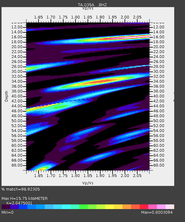
| Estimated Moho Depth: |
15.75 km |
| Estimated Crust Vp/Vs: |
2.05 |
| Assumed Crust Vp: |
6.483 km/s |
| Estimated Crust Vs: |
3.166 km/s |
| Estimated Crust Poisson's Ratio: |
0.34 |
|
| Radial Match: |
96.92305 % |
| Radial Bump: |
400 |
| Transverse Match: |
86.90816 % |
| Transverse Bump: |
400 |
| SOD ConfigId: |
410809 |
| Insert Time: |
2012-01-06 06:59:01.611 +0000 |
| GWidth: |
2.5 |
| Max Bumps: |
400 |
| Tol: |
0.001 |
|

Signal To Noise
| Channel | StoN | STA | LTA |
| TA:Q35A: :BHZ:20110817T11:56:21.049993Z | 45.4461 | 3.3037347E-6 | 7.269567E-8 |
| TA:Q35A: :BHN:20110817T11:56:21.049993Z | 13.696217 | 8.5278594E-7 | 6.226434E-8 |
| TA:Q35A: :BHE:20110817T11:56:21.049993Z | 12.169588 | 6.825449E-7 | 5.6086115E-8 |
| Arrivals |
| Ps | 2.6 SECOND |
| PpPs | 7.3 SECOND |
| PsPs/PpSs | 9.9 SECOND |


