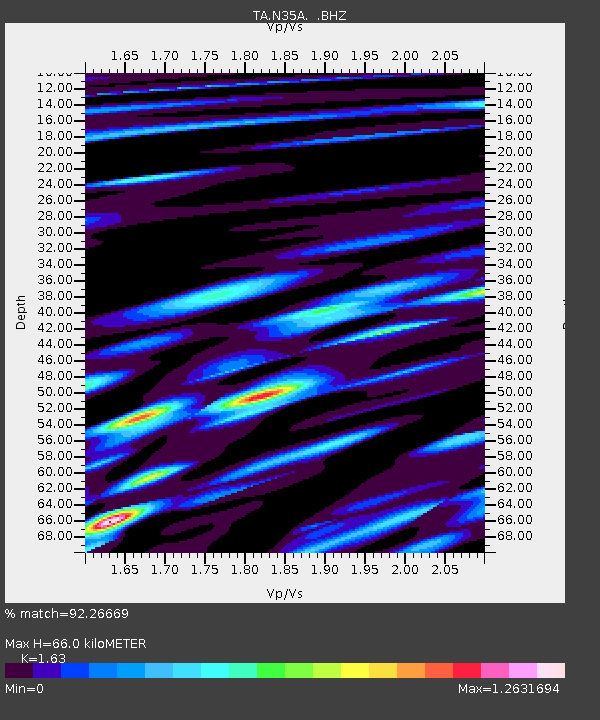
N35A Tabor, IA, USA - Earthquake Result Viewer
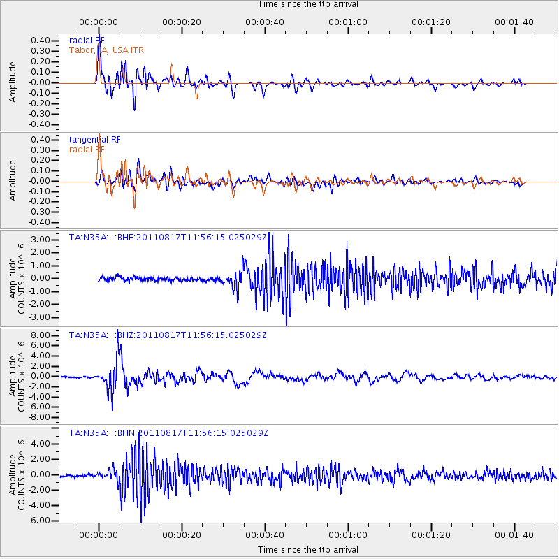
Earthquake location: Off East Coast Of Honshu, Japan
Earthquake latitude/longitude: 36.8/143.8
Earthquake time(UTC): 2011/08/17 (229) 11:44:08 GMT
Earthquake Depth: 9.0 km
Earthquake Magnitude: 6.1 MB, 5.8 MS, 6.2 MW, 6.1 MW
Earthquake Catalog/Contributor: WHDF/NEIC
Network: TA USArray Transportable Network (new EarthScope stations)
Station: N35A Tabor, IA, USA
Lat/Lon: 40.86 N/95.64 W
Elevation: 353 m
Distance: 85.5 deg
Az: 40.916 deg
Baz: 316.099 deg
Ray Param: 0.044721898
Estimated Moho Depth: 66.0 km
Estimated Crust Vp/Vs: 1.63
Assumed Crust Vp: 6.498 km/s
Estimated Crust Vs: 3.986 km/s
Estimated Crust Poisson's Ratio: 0.20
Radial Match: 92.26669 %
Radial Bump: 400
Transverse Match: 75.76983 %
Transverse Bump: 400
SOD ConfigId: 410809
Insert Time: 2012-01-06 06:59:14.689 +0000
GWidth: 2.5
Max Bumps: 400
Tol: 0.001

Signal To Noise

ChannelStoNSTALTA
TA:N35A: :BHZ:20110817T11:56:15.025029Z28.6042523.0045846E-61.05039796E-7
TA:N35A: :BHN:20110817T11:56:15.025029Z5.9895996.4227663E-71.0723198E-7
TA:N35A: :BHE:20110817T11:56:15.025029Z5.7723967.000813E-71.2128088E-7
Arrivals
Ps6.6 SECOND
PpPs26 SECOND
PsPs/PpSs33 SECOND