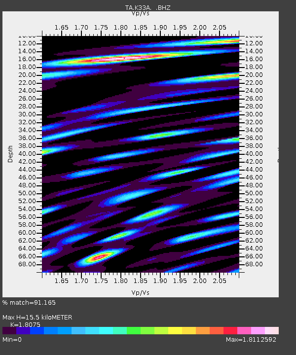
K33A Hardington, NE, USA - Earthquake Result Viewer

Earthquake location: Off East Coast Of Honshu, Japan
Earthquake latitude/longitude: 36.8/143.8
Earthquake time(UTC): 2011/08/17 (229) 11:44:08 GMT
Earthquake Depth: 9.0 km
Earthquake Magnitude: 6.1 MB, 5.8 MS, 6.2 MW, 6.1 MW
Earthquake Catalog/Contributor: WHDF/NEIC
Network: TA USArray Transportable Network (new EarthScope stations)
Station: K33A Hardington, NE, USA
Lat/Lon: 42.61 N/97.00 W
Elevation: 507 m
Distance: 83.5 deg
Az: 40.422 deg
Baz: 315.15 deg
Ray Param: 0.04611548
Estimated Moho Depth: 15.5 km
Estimated Crust Vp/Vs: 1.81
Assumed Crust Vp: 6.498 km/s
Estimated Crust Vs: 3.595 km/s
Estimated Crust Poisson's Ratio: 0.28
Radial Match: 91.165 %
Radial Bump: 400
Transverse Match: 85.6715 %
Transverse Bump: 400
SOD ConfigId: 410809
Insert Time: 2012-01-06 07:02:26.488 +0000
GWidth: 2.5
Max Bumps: 400
Tol: 0.001

Signal To Noise

ChannelStoNSTALTA
TA:K33A: :BHZ:20110817T11:56:05.174993Z26.5446683.3108338E-61.2472688E-7
TA:K33A: :BHN:20110817T11:56:05.174993Z8.7255061.2810839E-61.4682057E-7
TA:K33A: :BHE:20110817T11:56:05.174993Z13.5550921.899618E-61.4014054E-7
Arrivals
Ps2.0 SECOND
PpPs6.5 SECOND
PsPs/PpSs8.5 SECOND