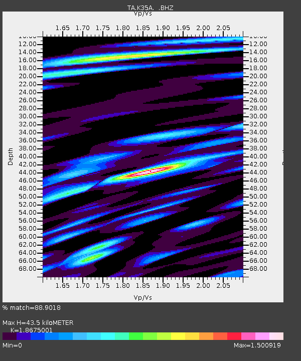
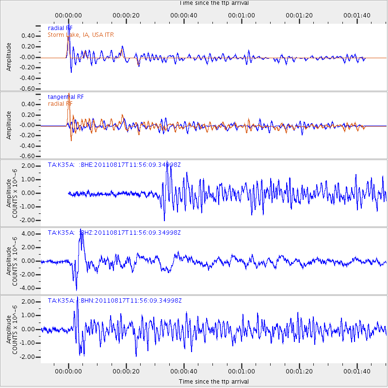
K35A Storm Lake, IA, USA - Earthquake Result Viewer

Earthquake location: Off East Coast Of Honshu, Japan
Earthquake latitude/longitude: 36.8/143.8
Earthquake time(UTC): 2011/08/17 (229) 11:44:08 GMT
Earthquake Depth: 9.0 km
Earthquake Magnitude: 6.1 MB, 5.8 MS, 6.2 MW, 6.1 MW
Earthquake Catalog/Contributor: WHDF/NEIC
Network: TA USArray Transportable Network (new EarthScope stations)
Station: K35A Storm Lake, IA, USA
Lat/Lon: 42.72 N/95.23 W
Elevation: 439 m
Distance: 84.4 deg
Az: 39.401 deg
Baz: 316.237 deg
Ray Param: 0.04553348
Estimated Moho Depth: 43.5 km
Estimated Crust Vp/Vs: 1.87
Assumed Crust Vp: 6.53 km/s
Estimated Crust Vs: 3.497 km/s
Estimated Crust Poisson's Ratio: 0.30
Radial Match: 88.9018 %
Radial Bump: 400
Transverse Match: 76.752594 %
Transverse Bump: 400
SOD ConfigId: 410809
Insert Time: 2012-01-06 07:03:41.687 +0000
GWidth: 2.5
Max Bumps: 400
Tol: 0.001

Signal To Noise

ChannelStoNSTALTA
TA:K35A: :BHZ:20110817T11:56:09.34998Z23.843022.0890375E-68.7616314E-8
TA:K35A: :BHN:20110817T11:56:09.34998Z9.4458499.204592E-79.7445884E-8
TA:K35A: :BHE:20110817T11:56:09.34998Z10.0119988.692175E-78.6817586E-8
Arrivals
Ps5.9 SECOND
PpPs19 SECOND
PsPs/PpSs25 SECOND