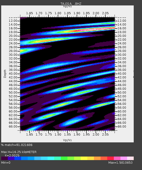
J31A Geddes, SD, USA - Earthquake Result Viewer
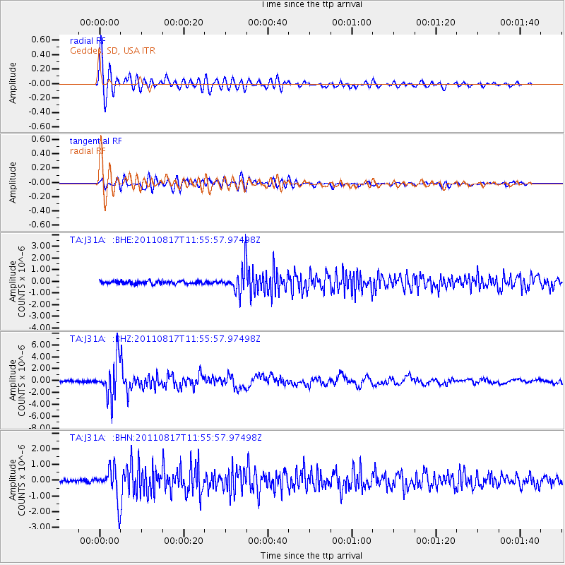
Earthquake location: Off East Coast Of Honshu, Japan
Earthquake latitude/longitude: 36.8/143.8
Earthquake time(UTC): 2011/08/17 (229) 11:44:08 GMT
Earthquake Depth: 9.0 km
Earthquake Magnitude: 6.1 MB, 5.8 MS, 6.2 MW, 6.1 MW
Earthquake Catalog/Contributor: WHDF/NEIC
Network: TA USArray Transportable Network (new EarthScope stations)
Station: J31A Geddes, SD, USA
Lat/Lon: 43.29 N/98.74 W
Elevation: 491 m
Distance: 82.2 deg
Az: 40.832 deg
Baz: 314.021 deg
Ray Param: 0.047087107
Estimated Moho Depth: 16.25 km
Estimated Crust Vp/Vs: 2.00
Assumed Crust Vp: 6.53 km/s
Estimated Crust Vs: 3.261 km/s
Estimated Crust Poisson's Ratio: 0.33
Radial Match: 91.821686 %
Radial Bump: 400
Transverse Match: 76.230286 %
Transverse Bump: 400
SOD ConfigId: 410809
Insert Time: 2012-01-06 07:04:28.518 +0000
GWidth: 2.5
Max Bumps: 400
Tol: 0.001

Signal To Noise

ChannelStoNSTALTA
TA:J31A: :BHZ:20110817T11:55:57.97498Z20.658573.0881E-61.4948274E-7
TA:J31A: :BHN:20110817T11:55:57.97498Z10.320011.0193772E-69.8776766E-8
TA:J31A: :BHE:20110817T11:55:57.97498Z9.4500891.1362616E-61.2023818E-7
Arrivals
Ps2.6 SECOND
PpPs7.3 SECOND
PsPs/PpSs9.8 SECOND