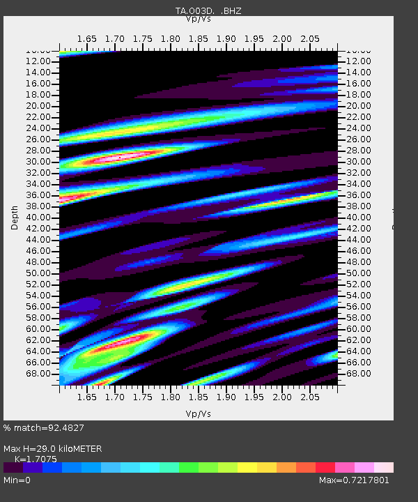
O03D Paynes Creek, CA, USA - Earthquake Result Viewer
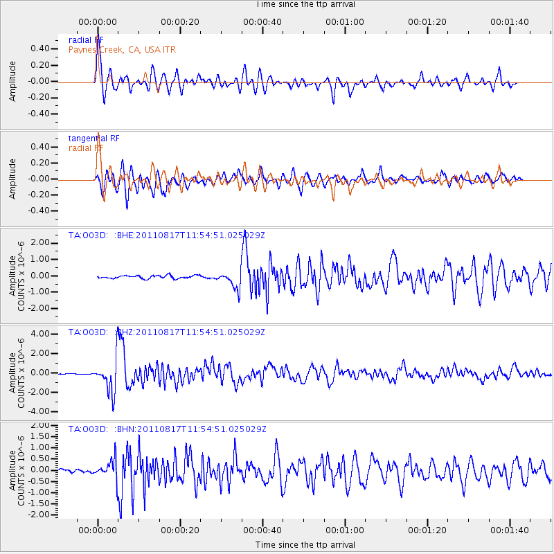
Earthquake location: Off East Coast Of Honshu, Japan
Earthquake latitude/longitude: 36.8/143.8
Earthquake time(UTC): 2011/08/17 (229) 11:44:08 GMT
Earthquake Depth: 9.0 km
Earthquake Magnitude: 6.1 MB, 5.8 MS, 6.2 MW, 6.1 MW
Earthquake Catalog/Contributor: WHDF/NEIC
Network: TA USArray Transportable Network (new EarthScope stations)
Station: O03D Paynes Creek, CA, USA
Lat/Lon: 40.29 N/121.80 W
Elevation: 968 m
Distance: 70.3 deg
Az: 54.077 deg
Baz: 301.767 deg
Ray Param: 0.055051904
Estimated Moho Depth: 29.0 km
Estimated Crust Vp/Vs: 1.71
Assumed Crust Vp: 6.566 km/s
Estimated Crust Vs: 3.845 km/s
Estimated Crust Poisson's Ratio: 0.24
Radial Match: 92.4827 %
Radial Bump: 400
Transverse Match: 82.10555 %
Transverse Bump: 400
SOD ConfigId: 410809
Insert Time: 2012-01-06 07:04:53.555 +0000
GWidth: 2.5
Max Bumps: 400
Tol: 0.001

Signal To Noise

ChannelStoNSTALTA
TA:O03D: :BHZ:20110817T11:54:51.025029Z20.1862681.797461E-68.9043745E-8
TA:O03D: :BHN:20110817T11:54:51.025029Z4.96910674.374704E-78.8038036E-8
TA:O03D: :BHE:20110817T11:54:51.025029Z5.9596355.4755134E-79.1876664E-8
Arrivals
Ps3.3 SECOND
PpPs11 SECOND
PsPs/PpSs15 SECOND