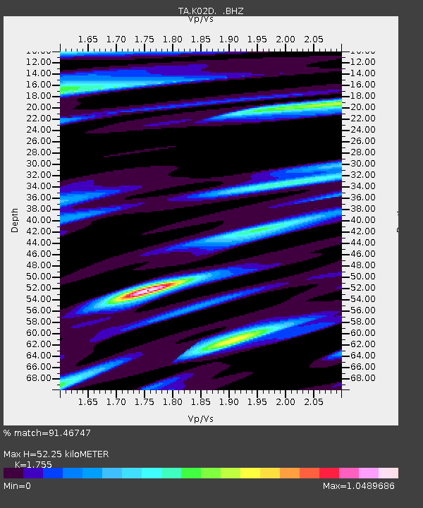
K02D Willamette Meridian, OR, USA - Earthquake Result Viewer
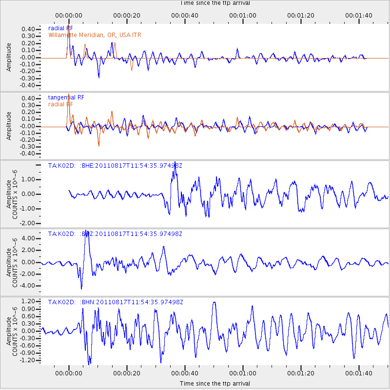
Earthquake location: Off East Coast Of Honshu, Japan
Earthquake latitude/longitude: 36.8/143.8
Earthquake time(UTC): 2011/08/17 (229) 11:44:08 GMT
Earthquake Depth: 9.0 km
Earthquake Magnitude: 6.1 MB, 5.8 MS, 6.2 MW, 6.1 MW
Earthquake Catalog/Contributor: WHDF/NEIC
Network: TA USArray Transportable Network (new EarthScope stations)
Station: K02D Willamette Meridian, OR, USA
Lat/Lon: 42.70 N/123.67 W
Elevation: 989 m
Distance: 67.9 deg
Az: 52.643 deg
Baz: 300.025 deg
Ray Param: 0.056654707
Estimated Moho Depth: 52.25 km
Estimated Crust Vp/Vs: 1.75
Assumed Crust Vp: 6.522 km/s
Estimated Crust Vs: 3.716 km/s
Estimated Crust Poisson's Ratio: 0.26
Radial Match: 91.46747 %
Radial Bump: 400
Transverse Match: 80.488045 %
Transverse Bump: 400
SOD ConfigId: 410809
Insert Time: 2012-01-06 07:04:54.510 +0000
GWidth: 2.5
Max Bumps: 400
Tol: 0.001

Signal To Noise

ChannelStoNSTALTA
TA:K02D: :BHZ:20110817T11:54:35.97498Z11.2941331.4227538E-61.2597282E-7
TA:K02D: :BHN:20110817T11:54:35.97498Z2.17946722.6940936E-71.2361248E-7
TA:K02D: :BHE:20110817T11:54:35.97498Z3.40267635.123069E-71.5055997E-7
Arrivals
Ps6.3 SECOND
PpPs21 SECOND
PsPs/PpSs27 SECOND