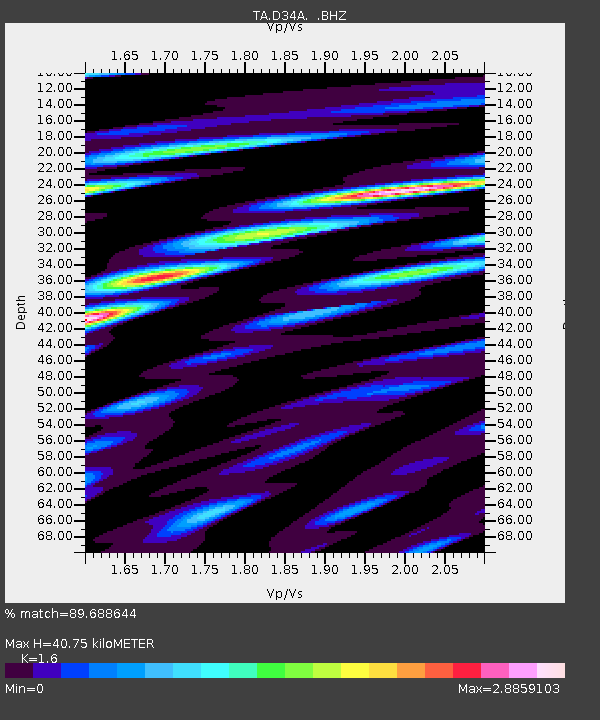
D34A Park Rapids, MN, USA - Earthquake Result Viewer
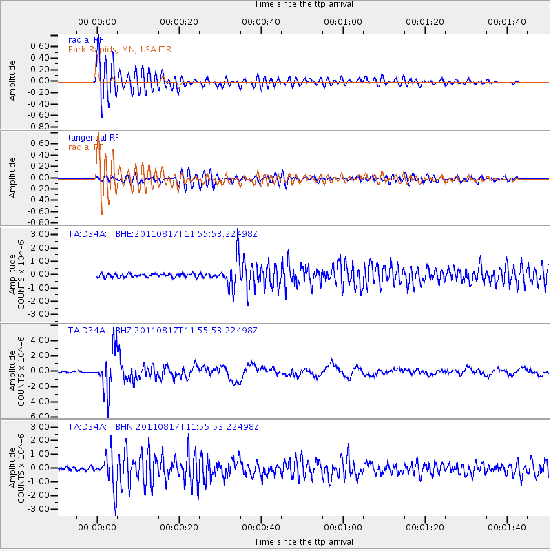
Earthquake location: Off East Coast Of Honshu, Japan
Earthquake latitude/longitude: 36.8/143.8
Earthquake time(UTC): 2011/08/17 (229) 11:44:08 GMT
Earthquake Depth: 9.0 km
Earthquake Magnitude: 6.1 MB, 5.8 MS, 6.2 MW, 6.1 MW
Earthquake Catalog/Contributor: WHDF/NEIC
Network: TA USArray Transportable Network (new EarthScope stations)
Station: D34A Park Rapids, MN, USA
Lat/Lon: 47.09 N/95.20 W
Elevation: 476 m
Distance: 81.2 deg
Az: 36.33 deg
Baz: 315.879 deg
Ray Param: 0.04772289
Estimated Moho Depth: 40.75 km
Estimated Crust Vp/Vs: 1.60
Assumed Crust Vp: 6.419 km/s
Estimated Crust Vs: 4.012 km/s
Estimated Crust Poisson's Ratio: 0.18
Radial Match: 89.688644 %
Radial Bump: 400
Transverse Match: 65.53994 %
Transverse Bump: 400
SOD ConfigId: 410809
Insert Time: 2012-01-06 07:07:05.429 +0000
GWidth: 2.5
Max Bumps: 400
Tol: 0.001

Signal To Noise

ChannelStoNSTALTA
TA:D34A: :BHZ:20110817T11:55:53.22498Z43.4968222.5747224E-65.9193344E-8
TA:D34A: :BHN:20110817T11:55:53.22498Z9.8958571.2658095E-61.2791308E-7
TA:D34A: :BHE:20110817T11:55:53.22498Z9.5620571.1268321E-61.17844124E-7
Arrivals
Ps3.9 SECOND
PpPs16 SECOND
PsPs/PpSs20 SECOND