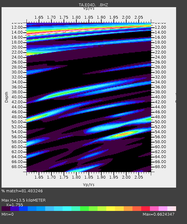
E04D Cinebar, WA, USA - Earthquake Result Viewer

Earthquake location: Off East Coast Of Honshu, Japan
Earthquake latitude/longitude: 36.8/143.8
Earthquake time(UTC): 2011/08/17 (229) 11:44:08 GMT
Earthquake Depth: 9.0 km
Earthquake Magnitude: 6.1 MB, 5.8 MS, 6.2 MW, 6.1 MW
Earthquake Catalog/Contributor: WHDF/NEIC
Network: TA USArray Transportable Network (new EarthScope stations)
Station: E04D Cinebar, WA, USA
Lat/Lon: 46.56 N/122.57 W
Elevation: 204 m
Distance: 66.7 deg
Az: 48.585 deg
Baz: 299.227 deg
Ray Param: 0.057460077
Estimated Moho Depth: 13.5 km
Estimated Crust Vp/Vs: 1.75
Assumed Crust Vp: 6.566 km/s
Estimated Crust Vs: 3.741 km/s
Estimated Crust Poisson's Ratio: 0.26
Radial Match: 81.483246 %
Radial Bump: 400
Transverse Match: 74.29993 %
Transverse Bump: 400
SOD ConfigId: 410809
Insert Time: 2012-01-06 07:07:18.414 +0000
GWidth: 2.5
Max Bumps: 400
Tol: 0.001

Signal To Noise

ChannelStoNSTALTA
TA:E04D: :BHZ:20110817T11:54:28.200017Z19.0135522.0191596E-61.0619582E-7
TA:E04D: :BHN:20110817T11:54:28.200017Z2.77954083.4132557E-71.2279928E-7
TA:E04D: :BHE:20110817T11:54:28.200017Z5.71082645.1254653E-78.9749975E-8
Arrivals
Ps1.6 SECOND
PpPs5.4 SECOND
PsPs/PpSs7.0 SECOND