You are here: Home > Network List > G - GEOSCOPE Stations List
> Station DRV Dumont d'Urville, Terre Adelie (Antartica) > Earthquake Result Viewer
DRV Dumont d'Urville, Terre Adelie (Antartica) - Earthquake Result Viewer
| Earthquake location: |
South Sandwich Islands Region |
| Earthquake latitude/longitude: |
-55.6/-29.9 |
| Earthquake time(UTC): |
2000/11/07 (312) 00:18:04 GMT |
| Earthquake Depth: |
10 km |
| Earthquake Magnitude: |
6.7 MS, 6.8 MW, 6.6 MW |
| Earthquake Catalog/Contributor: |
WHDF/NEIC |
|
| Network: |
G GEOSCOPE |
| Station: |
DRV Dumont d'Urville, Terre Adelie (Antartica) |
| Lat/Lon: |
66.67 S/140.01 E |
| Elevation: |
40 m |
|
| Distance: |
57.8 deg |
| Az: |
175.258 deg |
| Baz: |
186.76 deg |
| Ray Param: |
0.06326624 |
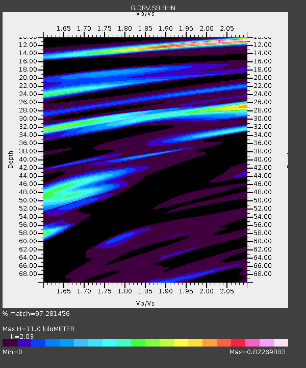
| Estimated Moho Depth: |
11.0 km |
| Estimated Crust Vp/Vs: |
2.03 |
| Assumed Crust Vp: |
6.39 km/s |
| Estimated Crust Vs: |
3.148 km/s |
| Estimated Crust Poisson's Ratio: |
0.34 |
|
| Radial Match: |
97.281456 % |
| Radial Bump: |
369 |
| Transverse Match: |
86.08897 % |
| Transverse Bump: |
400 |
| SOD ConfigId: |
3744 |
| Insert Time: |
2010-02-26 22:05:35.752 +0000 |
| GWidth: |
2.5 |
| Max Bumps: |
400 |
| Tol: |
0.001 |
|
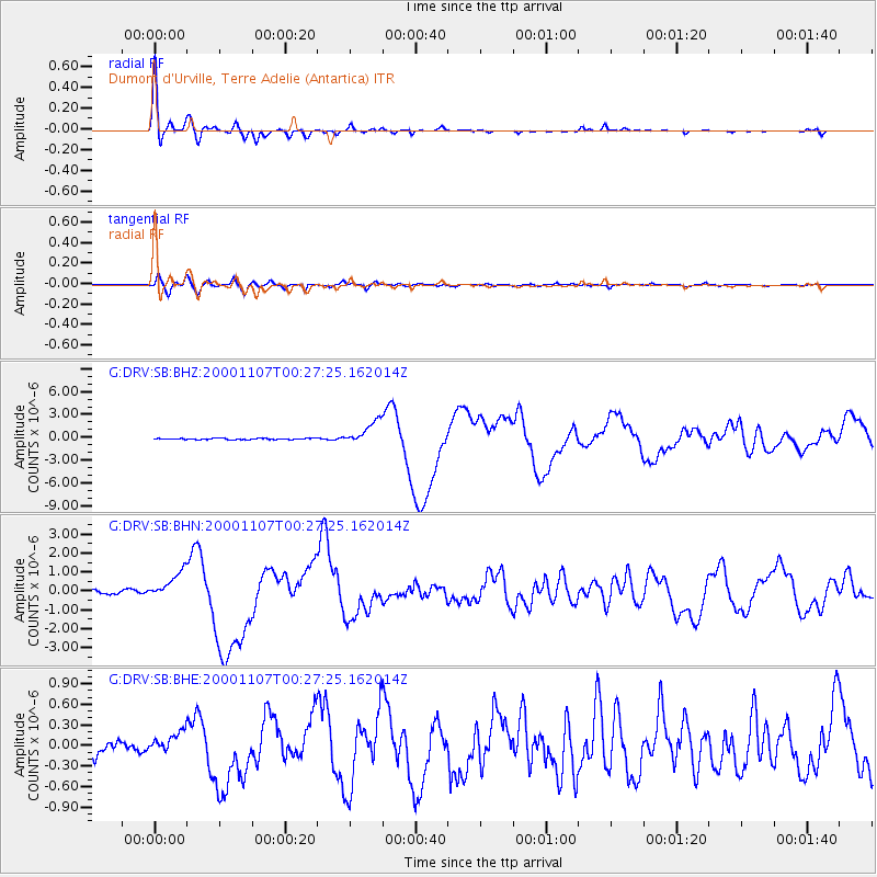
Signal To Noise
| Channel | StoN | STA | LTA |
| G:DRV:SB:BHN:20001107T00:27:25.162014Z | 8.634022 | 7.4390334E-7 | 8.615954E-8 |
| G:DRV:SB:BHE:20001107T00:27:25.162014Z | 2.06064 | 1.698073E-7 | 8.2405116E-8 |
| G:DRV:SB:BHZ:20001107T00:27:25.162014Z | 18.268463 | 1.5396361E-6 | 8.427836E-8 |
| Arrivals |
| Ps | 1.9 SECOND |
| PpPs | 5.0 SECOND |
| PsPs/PpSs | 6.8 SECOND |


