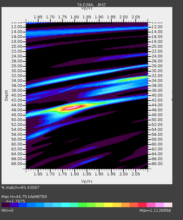
D36A Goodland, MN, USA - Earthquake Result Viewer
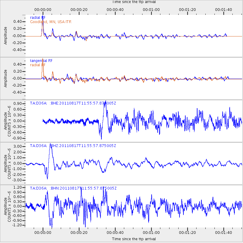
Earthquake location: Off East Coast Of Honshu, Japan
Earthquake latitude/longitude: 36.8/143.8
Earthquake time(UTC): 2011/08/17 (229) 11:44:08 GMT
Earthquake Depth: 9.0 km
Earthquake Magnitude: 6.1 MB, 5.8 MS, 6.2 MW, 6.1 MW
Earthquake Catalog/Contributor: WHDF/NEIC
Network: TA USArray Transportable Network (new EarthScope stations)
Station: D36A Goodland, MN, USA
Lat/Lon: 47.18 N/93.16 W
Elevation: 434 m
Distance: 82.1 deg
Az: 35.25 deg
Baz: 317.206 deg
Ray Param: 0.047099754
Estimated Moho Depth: 44.75 km
Estimated Crust Vp/Vs: 1.79
Assumed Crust Vp: 6.571 km/s
Estimated Crust Vs: 3.676 km/s
Estimated Crust Poisson's Ratio: 0.27
Radial Match: 93.43087 %
Radial Bump: 400
Transverse Match: 78.5726 %
Transverse Bump: 400
SOD ConfigId: 410809
Insert Time: 2012-01-06 07:07:45.350 +0000
GWidth: 2.5
Max Bumps: 400
Tol: 0.001

Signal To Noise

ChannelStoNSTALTA
TA:D36A: :BHZ:20110817T11:55:57.875005Z24.8349591.7985203E-67.24189E-8
TA:D36A: :BHN:20110817T11:55:57.875005Z5.95337155.872207E-79.863666E-8
TA:D36A: :BHE:20110817T11:55:57.875005Z7.64725735.2485467E-76.8633064E-8
Arrivals
Ps5.5 SECOND
PpPs18 SECOND
PsPs/PpSs24 SECOND