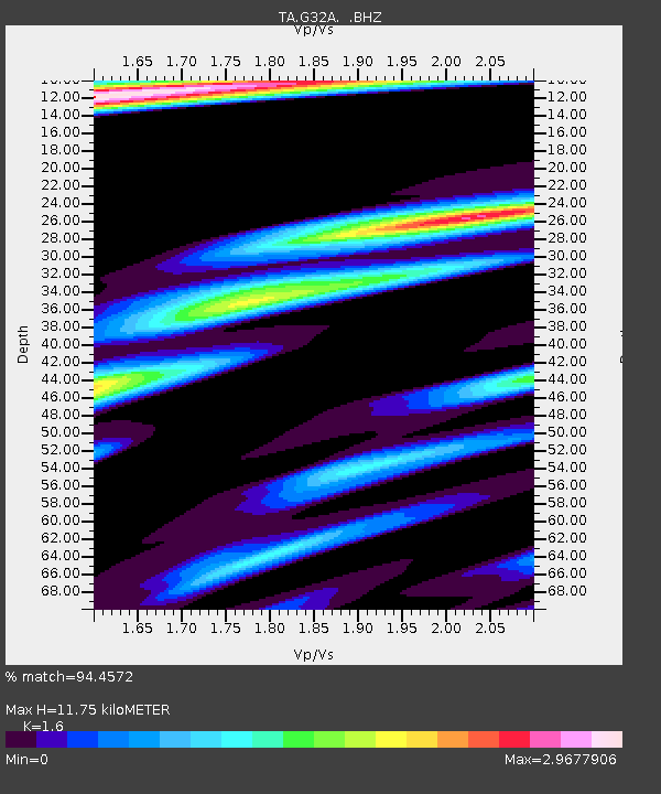
G32A Webster, SD, USA - Earthquake Result Viewer

Earthquake location: Off East Coast Of Honshu, Japan
Earthquake latitude/longitude: 36.8/143.8
Earthquake time(UTC): 2011/08/17 (229) 11:44:08 GMT
Earthquake Depth: 9.0 km
Earthquake Magnitude: 6.1 MB, 5.8 MS, 6.2 MW, 6.1 MW
Earthquake Catalog/Contributor: WHDF/NEIC
Network: TA USArray Transportable Network (new EarthScope stations)
Station: G32A Webster, SD, USA
Lat/Lon: 45.26 N/97.50 W
Elevation: 566 m
Distance: 81.4 deg
Az: 38.784 deg
Baz: 314.591 deg
Ray Param: 0.04760234
Estimated Moho Depth: 11.75 km
Estimated Crust Vp/Vs: 1.60
Assumed Crust Vp: 6.552 km/s
Estimated Crust Vs: 4.095 km/s
Estimated Crust Poisson's Ratio: 0.18
Radial Match: 94.4572 %
Radial Bump: 400
Transverse Match: 85.642 %
Transverse Bump: 400
SOD ConfigId: 410809
Insert Time: 2012-01-06 07:07:58.336 +0000
GWidth: 2.5
Max Bumps: 400
Tol: 0.001

Signal To Noise

ChannelStoNSTALTA
TA:G32A: :BHZ:20110817T11:55:54.125005Z38.8956643.8969947E-61.0019098E-7
TA:G32A: :BHN:20110817T11:55:54.125005Z3.97235941.1189708E-62.8168918E-7
TA:G32A: :BHE:20110817T11:55:54.125005Z7.2697481.0108226E-61.3904507E-7
Arrivals
Ps1.1 SECOND
PpPs4.5 SECOND
PsPs/PpSs5.6 SECOND