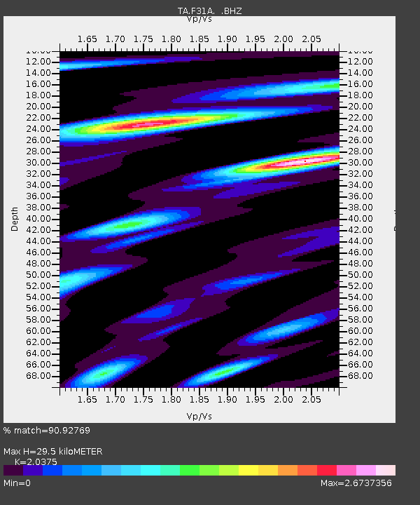
F31A Hecla, SD, USA - Earthquake Result Viewer

Earthquake location: Off East Coast Of Honshu, Japan
Earthquake latitude/longitude: 36.8/143.8
Earthquake time(UTC): 2011/08/17 (229) 11:44:08 GMT
Earthquake Depth: 9.0 km
Earthquake Magnitude: 6.1 MB, 5.8 MS, 6.2 MW, 6.1 MW
Earthquake Catalog/Contributor: WHDF/NEIC
Network: TA USArray Transportable Network (new EarthScope stations)
Station: F31A Hecla, SD, USA
Lat/Lon: 45.86 N/98.25 W
Elevation: 412 m
Distance: 80.6 deg
Az: 38.72 deg
Baz: 314.046 deg
Ray Param: 0.04815606
Estimated Moho Depth: 29.5 km
Estimated Crust Vp/Vs: 2.04
Assumed Crust Vp: 6.53 km/s
Estimated Crust Vs: 3.205 km/s
Estimated Crust Poisson's Ratio: 0.34
Radial Match: 90.92769 %
Radial Bump: 400
Transverse Match: 72.14809 %
Transverse Bump: 400
SOD ConfigId: 410809
Insert Time: 2012-01-06 07:08:11.606 +0000
GWidth: 2.5
Max Bumps: 400
Tol: 0.001

Signal To Noise

ChannelStoNSTALTA
TA:F31A: :BHZ:20110817T11:55:49.875005Z40.5290453.1981926E-67.891113E-8
TA:F31A: :BHN:20110817T11:55:49.875005Z8.0965211.0496719E-61.296448E-7
TA:F31A: :BHE:20110817T11:55:49.875005Z10.94243051.3598124E-61.2426969E-7
Arrivals
Ps4.8 SECOND
PpPs13 SECOND
PsPs/PpSs18 SECOND