You are here: Home > Network List > TA - USArray Transportable Network (new EarthScope stations) Stations List
> Station L37A Phoenix Point, Boone, IA, USA > Earthquake Result Viewer
L37A Phoenix Point, Boone, IA, USA - Earthquake Result Viewer
| Earthquake location: |
Off East Coast Of Honshu, Japan |
| Earthquake latitude/longitude: |
36.8/143.8 |
| Earthquake time(UTC): |
2011/08/17 (229) 11:44:08 GMT |
| Earthquake Depth: |
9.0 km |
| Earthquake Magnitude: |
6.1 MB, 5.8 MS, 6.2 MW, 6.1 MW |
| Earthquake Catalog/Contributor: |
WHDF/NEIC |
|
| Network: |
TA USArray Transportable Network (new EarthScope stations) |
| Station: |
L37A Phoenix Point, Boone, IA, USA |
| Lat/Lon: |
42.12 N/93.75 W |
| Elevation: |
312 m |
|
| Distance: |
85.6 deg |
| Az: |
39.012 deg |
| Baz: |
317.196 deg |
| Ray Param: |
0.044681873 |
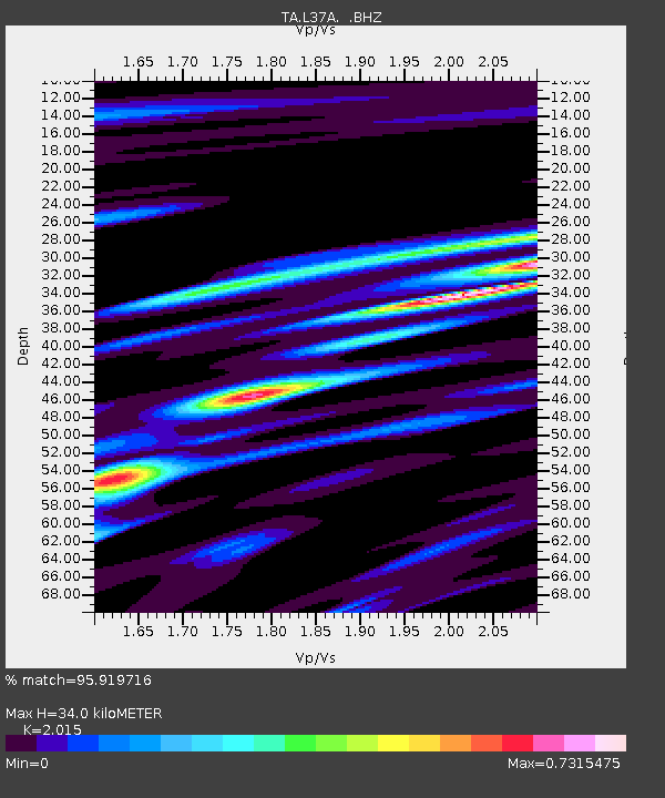
| Estimated Moho Depth: |
34.0 km |
| Estimated Crust Vp/Vs: |
2.02 |
| Assumed Crust Vp: |
6.53 km/s |
| Estimated Crust Vs: |
3.241 km/s |
| Estimated Crust Poisson's Ratio: |
0.34 |
|
| Radial Match: |
95.919716 % |
| Radial Bump: |
400 |
| Transverse Match: |
77.27251 % |
| Transverse Bump: |
400 |
| SOD ConfigId: |
410809 |
| Insert Time: |
2012-01-06 07:13:30.148 +0000 |
| GWidth: |
2.5 |
| Max Bumps: |
400 |
| Tol: |
0.001 |
|
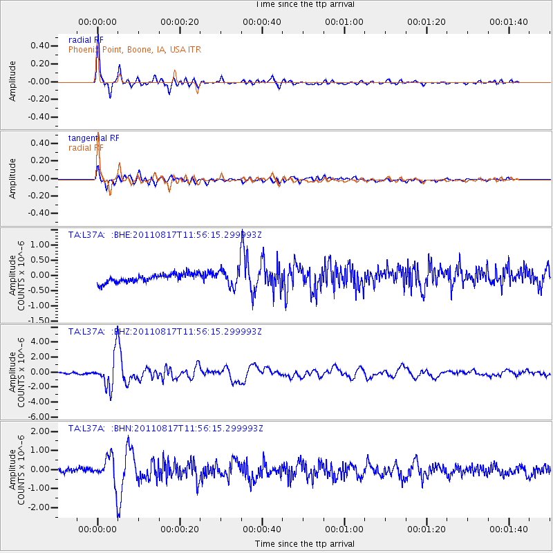
Signal To Noise
| Channel | StoN | STA | LTA |
| TA:L37A: :BHZ:20110817T11:56:15.299993Z | 31.980082 | 2.2638017E-6 | 7.078786E-8 |
| TA:L37A: :BHN:20110817T11:56:15.299993Z | 7.117858 | 7.7627345E-7 | 1.0905999E-7 |
| TA:L37A: :BHE:20110817T11:56:15.299993Z | 2.3491404 | 3.199959E-7 | 1.3621829E-7 |
| Arrivals |
| Ps | 5.4 SECOND |
| PpPs | 15 SECOND |
| PsPs/PpSs | 21 SECOND |


