You are here: Home > Network List > Z910 - Southeastern Suture of the Appalachian Margin Experiment Stations List
> Station E31 Griffin Property, Waynesboro, GA > Earthquake Result Viewer
E31 Griffin Property, Waynesboro, GA - Earthquake Result Viewer
| Earthquake location: |
Near Coast Of Northern Chile |
| Earthquake latitude/longitude: |
-20.8/-70.5 |
| Earthquake time(UTC): |
2014/04/03 (093) 05:26:16 GMT |
| Earthquake Depth: |
24 km |
| Earthquake Magnitude: |
6.2 MWP, 6.2 MWR, 6.3 MWW, 6.5 MWC |
| Earthquake Catalog/Contributor: |
NEIC PDE/NEIC COMCAT |
|
| Network: |
Z9 Southeastern Suture of the Appalachian Margin Experiment |
| Station: |
E31 Griffin Property, Waynesboro, GA |
| Lat/Lon: |
32.99 N/82.11 W |
| Elevation: |
78 m |
|
| Distance: |
54.6 deg |
| Az: |
348.08 deg |
| Baz: |
166.708 deg |
| Ray Param: |
0.065300494 |
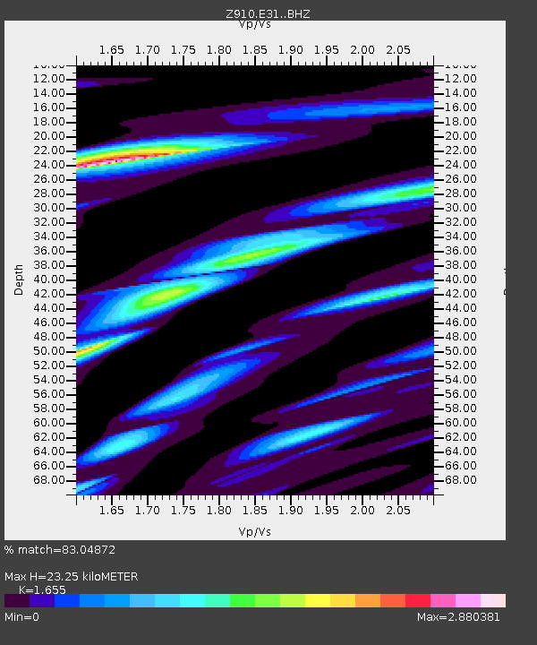
| Estimated Moho Depth: |
23.25 km |
| Estimated Crust Vp/Vs: |
1.65 |
| Assumed Crust Vp: |
6.565 km/s |
| Estimated Crust Vs: |
3.966 km/s |
| Estimated Crust Poisson's Ratio: |
0.21 |
|
| Radial Match: |
83.04872 % |
| Radial Bump: |
400 |
| Transverse Match: |
47.874596 % |
| Transverse Bump: |
400 |
| SOD ConfigId: |
3390531 |
| Insert Time: |
2019-04-11 02:47:56.671 +0000 |
| GWidth: |
2.5 |
| Max Bumps: |
400 |
| Tol: |
0.001 |
|

Signal To Noise
| Channel | StoN | STA | LTA |
| Z9:E31: :BHZ:20140403T05:35:10.400017Z | 6.739554 | 2.836347E-6 | 4.2085085E-7 |
| Z9:E31: :BHN:20140403T05:35:10.400017Z | 4.7823033 | 2.6634696E-6 | 5.5694284E-7 |
| Z9:E31: :BHE:20140403T05:35:10.400017Z | 0.9808441 | 3.9453437E-7 | 4.0223964E-7 |
| Arrivals |
| Ps | 2.5 SECOND |
| PpPs | 8.9 SECOND |
| PsPs/PpSs | 11 SECOND |


