You are here: Home > Network List > TA - USArray Transportable Network (new EarthScope stations) Stations List
> Station R38A Fenwick Farm, Montrose, MO, USA > Earthquake Result Viewer
R38A Fenwick Farm, Montrose, MO, USA - Earthquake Result Viewer
| Earthquake location: |
Off East Coast Of Honshu, Japan |
| Earthquake latitude/longitude: |
36.8/143.8 |
| Earthquake time(UTC): |
2011/08/17 (229) 11:44:08 GMT |
| Earthquake Depth: |
9.0 km |
| Earthquake Magnitude: |
6.1 MB, 5.8 MS, 6.2 MW, 6.1 MW |
| Earthquake Catalog/Contributor: |
WHDF/NEIC |
|
| Network: |
TA USArray Transportable Network (new EarthScope stations) |
| Station: |
R38A Fenwick Farm, Montrose, MO, USA |
| Lat/Lon: |
38.19 N/93.91 W |
| Elevation: |
237 m |
|
| Distance: |
88.4 deg |
| Az: |
41.772 deg |
| Baz: |
317.246 deg |
| Ray Param: |
0.04264316 |
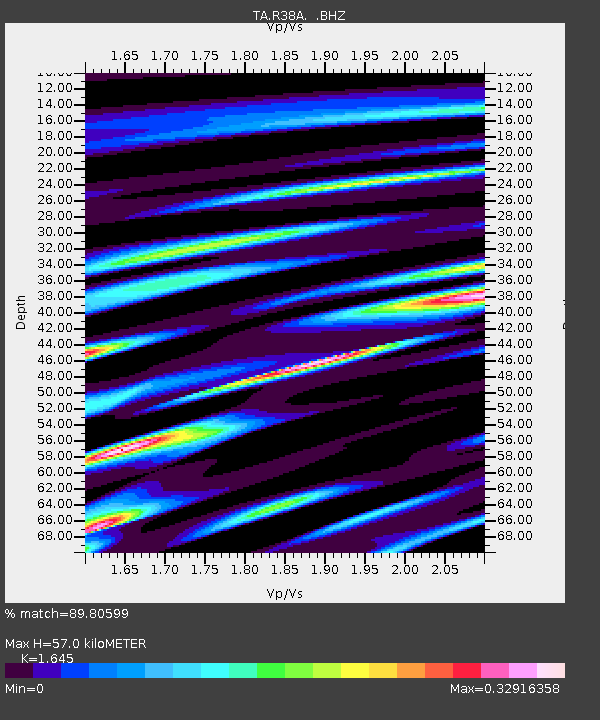
| Estimated Moho Depth: |
57.0 km |
| Estimated Crust Vp/Vs: |
1.64 |
| Assumed Crust Vp: |
6.498 km/s |
| Estimated Crust Vs: |
3.95 km/s |
| Estimated Crust Poisson's Ratio: |
0.21 |
|
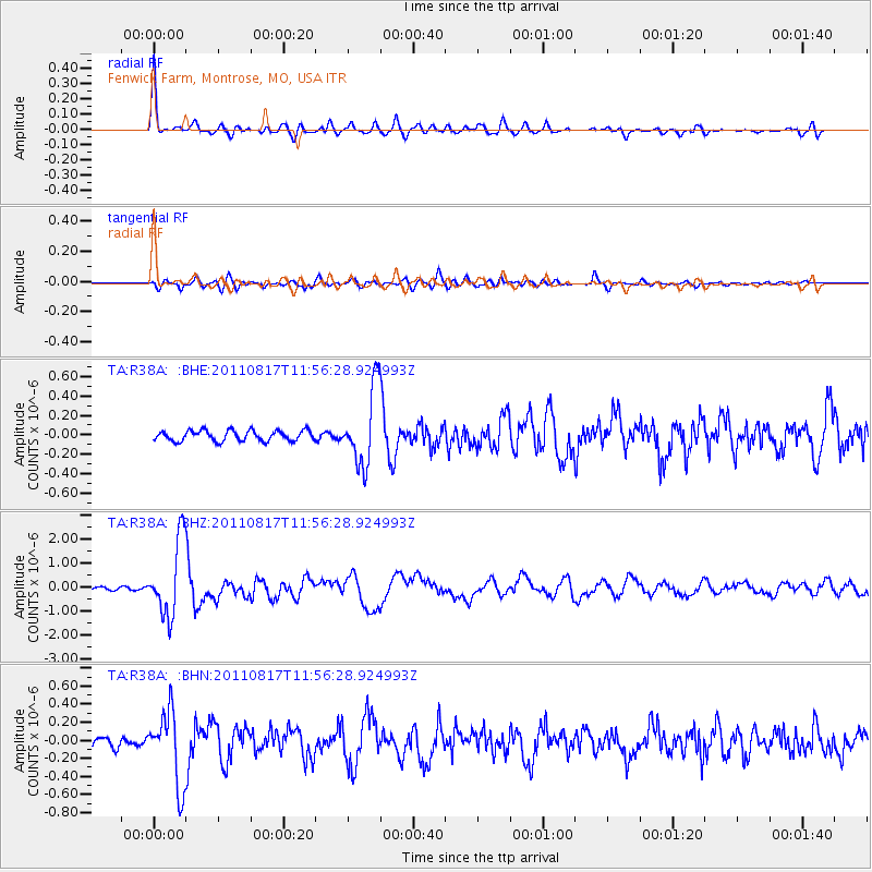
| Radial Match: |
89.80599 % |
| Radial Bump: |
400 |
| Transverse Match: |
79.00842 % |
| Transverse Bump: |
400 |
| SOD ConfigId: |
410809 |
| Insert Time: |
2012-01-06 07:14:35.615 +0000 |
| GWidth: |
2.5 |
| Max Bumps: |
400 |
| Tol: |
0.001 |
|
Signal To Noise
| Channel | StoN | STA | LTA |
| TA:R38A: :BHZ:20110817T11:56:28.924993Z | 27.150368 | 1.5835494E-6 | 5.8325156E-8 |
| TA:R38A: :BHN:20110817T11:56:28.924993Z | 8.099639 | 4.040564E-7 | 4.988573E-8 |
| TA:R38A: :BHE:20110817T11:56:28.924993Z | 7.401338 | 3.9675095E-7 | 5.36053E-8 |
| Arrivals |
| Ps | 5.8 SECOND |
| PpPs | 23 SECOND |
| PsPs/PpSs | 28 SECOND |


