You are here: Home > Network List > TA - USArray Transportable Network (new EarthScope stations) Stations List
> Station R40A Maddie's Station, St. Elizabeth, MO, USA > Earthquake Result Viewer
R40A Maddie's Station, St. Elizabeth, MO, USA - Earthquake Result Viewer
| Earthquake location: |
Off East Coast Of Honshu, Japan |
| Earthquake latitude/longitude: |
36.8/143.8 |
| Earthquake time(UTC): |
2011/08/17 (229) 11:44:08 GMT |
| Earthquake Depth: |
9.0 km |
| Earthquake Magnitude: |
6.1 MB, 5.8 MS, 6.2 MW, 6.1 MW |
| Earthquake Catalog/Contributor: |
WHDF/NEIC |
|
| Network: |
TA USArray Transportable Network (new EarthScope stations) |
| Station: |
R40A Maddie's Station, St. Elizabeth, MO, USA |
| Lat/Lon: |
38.29 N/92.27 W |
| Elevation: |
213 m |
|
| Distance: |
89.2 deg |
| Az: |
40.748 deg |
| Baz: |
318.233 deg |
| Ray Param: |
0.04205855 |
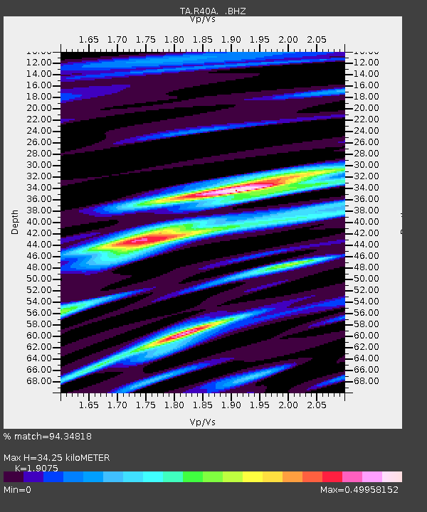
| Estimated Moho Depth: |
34.25 km |
| Estimated Crust Vp/Vs: |
1.91 |
| Assumed Crust Vp: |
6.498 km/s |
| Estimated Crust Vs: |
3.406 km/s |
| Estimated Crust Poisson's Ratio: |
0.31 |
|
| Radial Match: |
94.34818 % |
| Radial Bump: |
400 |
| Transverse Match: |
86.61369 % |
| Transverse Bump: |
400 |
| SOD ConfigId: |
410809 |
| Insert Time: |
2012-01-06 07:14:50.409 +0000 |
| GWidth: |
2.5 |
| Max Bumps: |
400 |
| Tol: |
0.001 |
|

Signal To Noise
| Channel | StoN | STA | LTA |
| TA:R40A: :BHZ:20110817T11:56:32.625005Z | 44.31758 | 2.1524074E-6 | 4.85678E-8 |
| TA:R40A: :BHN:20110817T11:56:32.625005Z | 8.958734 | 5.4760545E-7 | 6.112532E-8 |
| TA:R40A: :BHE:20110817T11:56:32.625005Z | 8.514662 | 4.5226022E-7 | 5.3115468E-8 |
| Arrivals |
| Ps | 4.9 SECOND |
| PpPs | 15 SECOND |
| PsPs/PpSs | 20 SECOND |


