You are here: Home > Network List > TA - USArray Transportable Network (new EarthScope stations) Stations List
> Station 348A Jackson, AL, USA > Earthquake Result Viewer
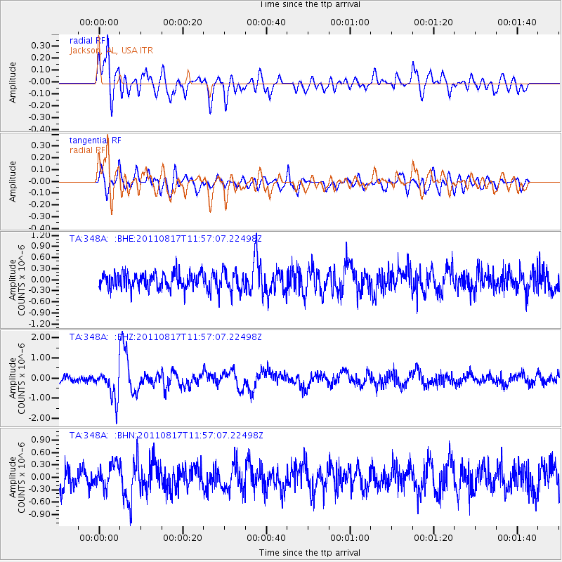
348A Jackson, AL, USA - Earthquake Result Viewer
*The percent match for this event was below the threshold and hence no stack was calculated.
| Earthquake location: |
Off East Coast Of Honshu, Japan |
| Earthquake latitude/longitude: |
36.8/143.8 |
| Earthquake time(UTC): |
2011/08/17 (229) 11:44:08 GMT |
| Earthquake Depth: |
9.0 km |
| Earthquake Magnitude: |
6.1 MB, 5.8 MS, 6.2 MW, 6.1 MW |
| Earthquake Catalog/Contributor: |
WHDF/NEIC |
|
| Network: |
TA USArray Transportable Network (new EarthScope stations) |
| Station: |
348A Jackson, AL, USA |
| Lat/Lon: |
31.41 N/87.90 W |
| Elevation: |
57 m |
|
| Distance: |
96.7 deg |
| Az: |
42.48 deg |
| Baz: |
320.633 deg |
| Ray Param: |
$rayparam |
*The percent match for this event was below the threshold and hence was not used in the summary stack. |
|
| Radial Match: |
76.1061 % |
| Radial Bump: |
400 |
| Transverse Match: |
64.75789 % |
| Transverse Bump: |
400 |
| SOD ConfigId: |
410809 |
| Insert Time: |
2012-01-06 07:19:42.865 +0000 |
| GWidth: |
2.5 |
| Max Bumps: |
400 |
| Tol: |
0.001 |
|
Signal To Noise
| Channel | StoN | STA | LTA |
| TA:348A: :BHZ:20110817T11:57:07.22498Z | 4.9196963 | 7.183824E-7 | 1.460217E-7 |
| TA:348A: :BHN:20110817T11:57:07.22498Z | 1.3732462 | 2.8196598E-7 | 2.0532806E-7 |
| TA:348A: :BHE:20110817T11:57:07.22498Z | 1.3438635 | 2.7184365E-7 | 2.0228518E-7 |
| Arrivals |
| Ps | |
| PpPs | |
| PsPs/PpSs | |


