You are here: Home > Network List > TA - USArray Transportable Network (new EarthScope stations) Stations List
> Station W41B Gary Mavity, Velonia, AR, USA > Earthquake Result Viewer
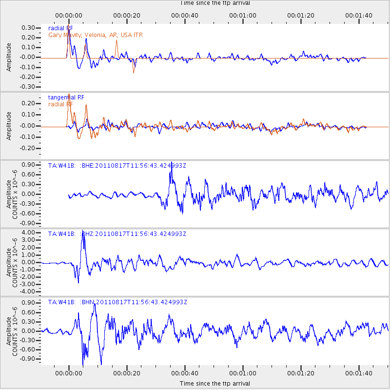
W41B Gary Mavity, Velonia, AR, USA - Earthquake Result Viewer
| Earthquake location: |
Off East Coast Of Honshu, Japan |
| Earthquake latitude/longitude: |
36.8/143.8 |
| Earthquake time(UTC): |
2011/08/17 (229) 11:44:08 GMT |
| Earthquake Depth: |
9.0 km |
| Earthquake Magnitude: |
6.1 MB, 5.8 MS, 6.2 MW, 6.1 MW |
| Earthquake Catalog/Contributor: |
WHDF/NEIC |
|
| Network: |
TA USArray Transportable Network (new EarthScope stations) |
| Station: |
W41B Gary Mavity, Velonia, AR, USA |
| Lat/Lon: |
35.17 N/92.25 W |
| Elevation: |
95 m |
|
| Distance: |
91.5 deg |
| Az: |
42.808 deg |
| Baz: |
318.233 deg |
| Ray Param: |
0.04159878 |
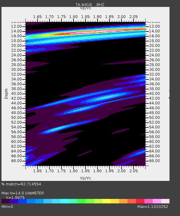
| Estimated Moho Depth: |
14.0 km |
| Estimated Crust Vp/Vs: |
1.89 |
| Assumed Crust Vp: |
6.498 km/s |
| Estimated Crust Vs: |
3.442 km/s |
| Estimated Crust Poisson's Ratio: |
0.30 |
|
| Radial Match: |
92.714554 % |
| Radial Bump: |
400 |
| Transverse Match: |
68.29684 % |
| Transverse Bump: |
400 |
| SOD ConfigId: |
410809 |
| Insert Time: |
2012-01-06 07:19:51.805 +0000 |
| GWidth: |
2.5 |
| Max Bumps: |
400 |
| Tol: |
0.001 |
|
Signal To Noise
| Channel | StoN | STA | LTA |
| TA:W41B: :BHZ:20110817T11:56:43.424993Z | 20.014957 | 1.4993317E-6 | 7.491056E-8 |
| TA:W41B: :BHN:20110817T11:56:43.424993Z | 4.1959662 | 2.7436784E-7 | 6.5388484E-8 |
| TA:W41B: :BHE:20110817T11:56:43.424993Z | 4.2820125 | 2.2349238E-7 | 5.2193307E-8 |
| Arrivals |
| Ps | 2.0 SECOND |
| PpPs | 6.1 SECOND |
| PsPs/PpSs | 8.0 SECOND |


