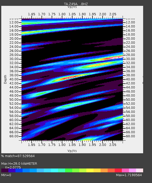
Z45A Winona, MS, USA - Earthquake Result Viewer

Earthquake location: Off East Coast Of Honshu, Japan
Earthquake latitude/longitude: 36.8/143.8
Earthquake time(UTC): 2011/08/17 (229) 11:44:08 GMT
Earthquake Depth: 9.0 km
Earthquake Magnitude: 6.1 MB, 5.8 MS, 6.2 MW, 6.1 MW
Earthquake Catalog/Contributor: WHDF/NEIC
Network: TA USArray Transportable Network (new EarthScope stations)
Station: Z45A Winona, MS, USA
Lat/Lon: 33.37 N/89.69 W
Elevation: 113 m
Distance: 94.2 deg
Az: 42.391 deg
Baz: 319.688 deg
Ray Param: 0.041092094
Estimated Moho Depth: 29.0 km
Estimated Crust Vp/Vs: 2.08
Assumed Crust Vp: 6.201 km/s
Estimated Crust Vs: 2.985 km/s
Estimated Crust Poisson's Ratio: 0.35
Radial Match: 87.529564 %
Radial Bump: 400
Transverse Match: 86.277954 %
Transverse Bump: 400
SOD ConfigId: 410809
Insert Time: 2012-01-06 07:20:46.135 +0000
GWidth: 2.5
Max Bumps: 400
Tol: 0.001

Signal To Noise

ChannelStoNSTALTA
TA:Z45A: :BHZ:20110817T11:56:56.025029Z4.9014869.535726E-71.9454767E-7
TA:Z45A: :BHN:20110817T11:56:56.025029Z1.39501323.8396706E-72.752426E-7
TA:Z45A: :BHE:20110817T11:56:56.025029Z1.18043723.7534429E-73.1797055E-7
Arrivals
Ps5.1 SECOND
PpPs14 SECOND
PsPs/PpSs19 SECOND