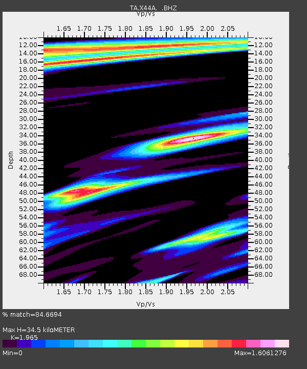
X44A Crenshaw, MS, USA - Earthquake Result Viewer
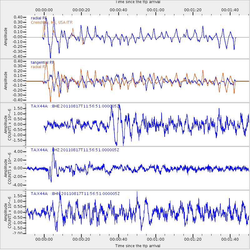
Earthquake location: Off East Coast Of Honshu, Japan
Earthquake latitude/longitude: 36.8/143.8
Earthquake time(UTC): 2011/08/17 (229) 11:44:08 GMT
Earthquake Depth: 9.0 km
Earthquake Magnitude: 6.1 MB, 5.8 MS, 6.2 MW, 6.1 MW
Earthquake Catalog/Contributor: WHDF/NEIC
Network: TA USArray Transportable Network (new EarthScope stations)
Station: X44A Crenshaw, MS, USA
Lat/Lon: 34.50 N/90.15 W
Elevation: 109 m
Distance: 93.1 deg
Az: 41.948 deg
Baz: 319.463 deg
Ray Param: 0.041322093
Estimated Moho Depth: 34.5 km
Estimated Crust Vp/Vs: 1.97
Assumed Crust Vp: 6.273 km/s
Estimated Crust Vs: 3.192 km/s
Estimated Crust Poisson's Ratio: 0.33
Radial Match: 84.6694 %
Radial Bump: 400
Transverse Match: 83.957405 %
Transverse Bump: 400
SOD ConfigId: 410809
Insert Time: 2012-01-06 07:21:13.208 +0000
GWidth: 2.5
Max Bumps: 400
Tol: 0.001

Signal To Noise

ChannelStoNSTALTA
TA:X44A: :BHZ:20110817T11:56:51.000005Z8.5234171.5480337E-61.8162123E-7
TA:X44A: :BHN:20110817T11:56:51.000005Z1.62462873.9376337E-72.423713E-7
TA:X44A: :BHE:20110817T11:56:51.000005Z1.33680763.2401505E-72.423797E-7
Arrivals
Ps5.4 SECOND
PpPs16 SECOND
PsPs/PpSs21 SECOND