You are here: Home > Network List > G - GEOSCOPE Stations List
> Station DRV Dumont d'Urville, Terre Adelie (Antartica) > Earthquake Result Viewer
DRV Dumont d'Urville, Terre Adelie (Antartica) - Earthquake Result Viewer
| Earthquake location: |
Sulawesi, Indonesia |
| Earthquake latitude/longitude: |
-1.1/123.6 |
| Earthquake time(UTC): |
2000/05/04 (125) 04:21:16 GMT |
| Earthquake Depth: |
26 km |
| Earthquake Magnitude: |
6.7 MB, 7.5 MS, 7.6 MW, 7.5 ME |
| Earthquake Catalog/Contributor: |
WHDF/NEIC |
|
| Network: |
G GEOSCOPE |
| Station: |
DRV Dumont d'Urville, Terre Adelie (Antartica) |
| Lat/Lon: |
66.67 S/140.01 E |
| Elevation: |
40 m |
|
| Distance: |
66.4 deg |
| Az: |
172.937 deg |
| Baz: |
342.024 deg |
| Ray Param: |
0.05757415 |
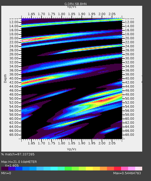
| Estimated Moho Depth: |
21.0 km |
| Estimated Crust Vp/Vs: |
1.61 |
| Assumed Crust Vp: |
6.39 km/s |
| Estimated Crust Vs: |
3.981 km/s |
| Estimated Crust Poisson's Ratio: |
0.18 |
|
| Radial Match: |
97.337265 % |
| Radial Bump: |
302 |
| Transverse Match: |
92.10139 % |
| Transverse Bump: |
400 |
| SOD ConfigId: |
3744 |
| Insert Time: |
2010-02-26 22:05:58.175 +0000 |
| GWidth: |
2.5 |
| Max Bumps: |
400 |
| Tol: |
0.001 |
|
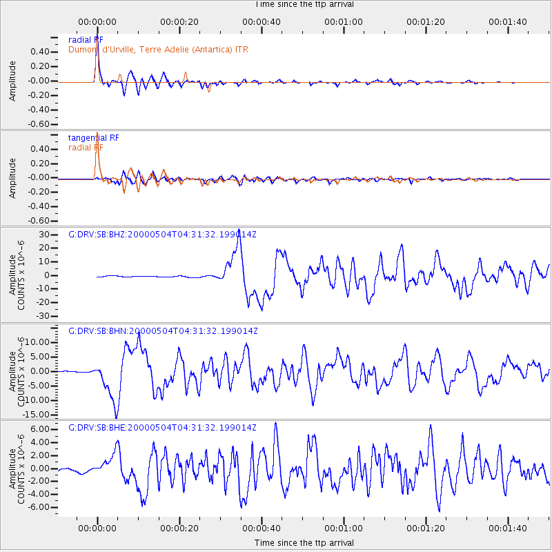
Signal To Noise
| Channel | StoN | STA | LTA |
| G:DRV:SB:BHN:20000504T04:31:32.199014Z | 23.616264 | 7.3802007E-6 | 3.12505E-7 |
| G:DRV:SB:BHE:20000504T04:31:32.199014Z | 6.4632325 | 1.9049523E-6 | 2.947368E-7 |
| G:DRV:SB:BHZ:20000504T04:31:32.199014Z | 32.34662 | 1.5116325E-5 | 4.6732316E-7 |
| Arrivals |
| Ps | 2.1 SECOND |
| PpPs | 8.2 SECOND |
| PsPs/PpSs | 10 SECOND |


