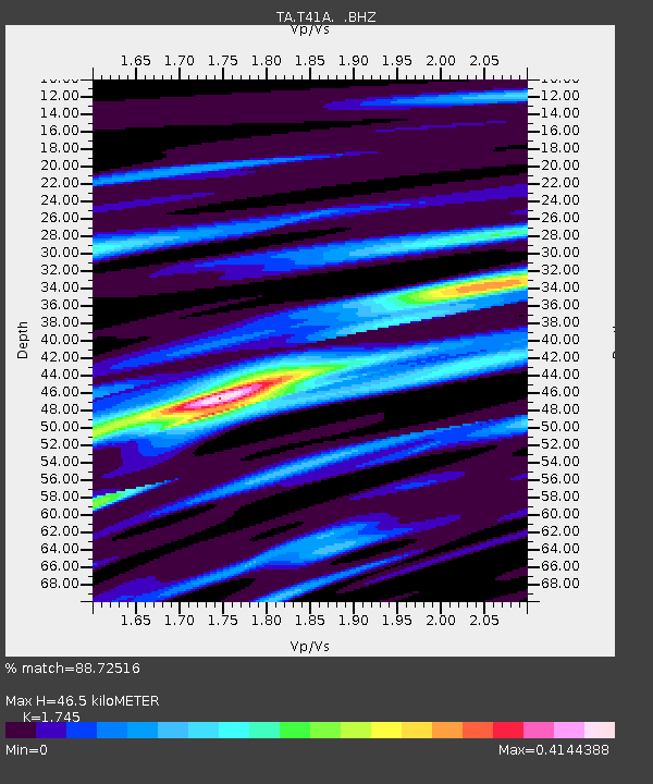
T41A Mountain View, MO, USA - Earthquake Result Viewer
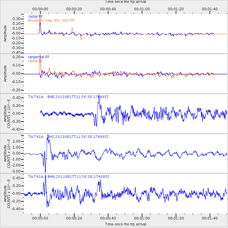
Earthquake location: Off East Coast Of Honshu, Japan
Earthquake latitude/longitude: 36.8/143.8
Earthquake time(UTC): 2011/08/17 (229) 11:44:08 GMT
Earthquake Depth: 9.0 km
Earthquake Magnitude: 6.1 MB, 5.8 MS, 6.2 MW, 6.1 MW
Earthquake Catalog/Contributor: WHDF/NEIC
Network: TA USArray Transportable Network (new EarthScope stations)
Station: T41A Mountain View, MO, USA
Lat/Lon: 37.04 N/91.76 W
Elevation: 366 m
Distance: 90.4 deg
Az: 41.275 deg
Baz: 318.542 deg
Ray Param: 0.041679718
Estimated Moho Depth: 46.5 km
Estimated Crust Vp/Vs: 1.75
Assumed Crust Vp: 6.53 km/s
Estimated Crust Vs: 3.742 km/s
Estimated Crust Poisson's Ratio: 0.26
Radial Match: 88.72516 %
Radial Bump: 400
Transverse Match: 85.17935 %
Transverse Bump: 400
SOD ConfigId: 410809
Insert Time: 2012-01-06 07:21:30.664 +0000
GWidth: 2.5
Max Bumps: 400
Tol: 0.001

Signal To Noise

ChannelStoNSTALTA
TA:T41A: :BHZ:20110817T11:56:38.174993Z23.4827021.4212021E-66.052123E-8
TA:T41A: :BHN:20110817T11:56:38.174993Z5.8853311.824036E-73.099292E-8
TA:T41A: :BHE:20110817T11:56:38.174993Z7.1642581.9700609E-72.7498464E-8
Arrivals
Ps5.4 SECOND
PpPs19 SECOND
PsPs/PpSs25 SECOND