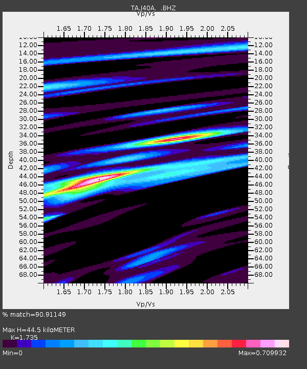
J40A Soldiers Grove, WI, USA - Earthquake Result Viewer

Earthquake location: Off East Coast Of Honshu, Japan
Earthquake latitude/longitude: 36.8/143.8
Earthquake time(UTC): 2011/08/17 (229) 11:44:08 GMT
Earthquake Depth: 9.0 km
Earthquake Magnitude: 6.1 MB, 5.8 MS, 6.2 MW, 6.1 MW
Earthquake Catalog/Contributor: WHDF/NEIC
Network: TA USArray Transportable Network (new EarthScope stations)
Station: J40A Soldiers Grove, WI, USA
Lat/Lon: 43.40 N/90.74 W
Elevation: 353 m
Distance: 86.1 deg
Az: 36.504 deg
Baz: 319.053 deg
Ray Param: 0.044300046
Estimated Moho Depth: 44.5 km
Estimated Crust Vp/Vs: 1.74
Assumed Crust Vp: 6.53 km/s
Estimated Crust Vs: 3.764 km/s
Estimated Crust Poisson's Ratio: 0.25
Radial Match: 90.91149 %
Radial Bump: 400
Transverse Match: 75.82678 %
Transverse Bump: 400
SOD ConfigId: 410809
Insert Time: 2012-01-06 07:23:18.362 +0000
GWidth: 2.5
Max Bumps: 400
Tol: 0.001

Signal To Noise

ChannelStoNSTALTA
TA:J40A: :BHZ:20110817T11:56:17.950017Z24.8381542.1240144E-68.551417E-8
TA:J40A: :BHN:20110817T11:56:17.950017Z6.4012644.72981E-77.3888685E-8
TA:J40A: :BHE:20110817T11:56:17.950017Z8.0978185.606003E-76.922856E-8
Arrivals
Ps5.1 SECOND
PpPs18 SECOND
PsPs/PpSs23 SECOND