You are here: Home > Network List > NE - New England Seismic Network Stations List
> Station HNH Hanover, NH, USA > Earthquake Result Viewer
HNH Hanover, NH, USA - Earthquake Result Viewer
| Earthquake location: |
Near Coast Of Northern Chile |
| Earthquake latitude/longitude: |
-20.8/-70.6 |
| Earthquake time(UTC): |
2014/04/03 (093) 05:28:50 GMT |
| Earthquake Depth: |
11 km |
| Earthquake Magnitude: |
5.6 mb |
| Earthquake Catalog/Contributor: |
ISC/ISC |
|
| Network: |
NE New England Seismic Network |
| Station: |
HNH Hanover, NH, USA |
| Lat/Lon: |
43.71 N/72.29 W |
| Elevation: |
180 m |
|
| Distance: |
64.2 deg |
| Az: |
358.623 deg |
| Baz: |
178.224 deg |
| Ray Param: |
0.05905063 |
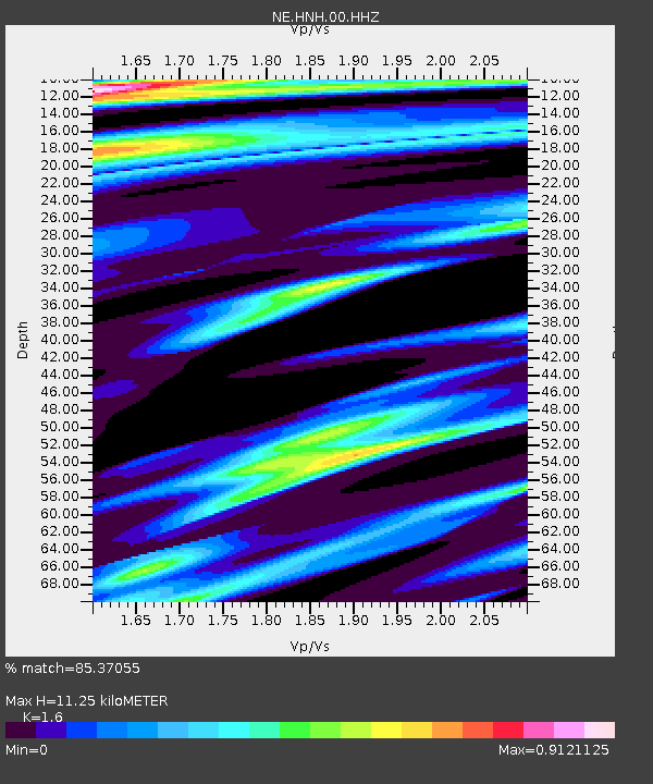
| Estimated Moho Depth: |
11.25 km |
| Estimated Crust Vp/Vs: |
1.60 |
| Assumed Crust Vp: |
6.419 km/s |
| Estimated Crust Vs: |
4.012 km/s |
| Estimated Crust Poisson's Ratio: |
0.18 |
|
| Radial Match: |
85.37055 % |
| Radial Bump: |
400 |
| Transverse Match: |
86.990395 % |
| Transverse Bump: |
400 |
| SOD ConfigId: |
3390531 |
| Insert Time: |
2019-04-11 02:51:07.375 +0000 |
| GWidth: |
2.5 |
| Max Bumps: |
400 |
| Tol: |
0.001 |
|

Signal To Noise
| Channel | StoN | STA | LTA |
| NE:HNH:00:HHZ:20140403T05:38:54.088984Z | 2.5214758 | 2.5946285E-6 | 1.0290119E-6 |
| NE:HNH:00:HH1:20140403T05:38:54.088984Z | 1.179008 | 1.101272E-6 | 9.3406663E-7 |
| NE:HNH:00:HH2:20140403T05:38:54.088984Z | 1.5145129 | 9.254808E-7 | 6.110749E-7 |
| Arrivals |
| Ps | 1.1 SECOND |
| PpPs | 4.3 SECOND |
| PsPs/PpSs | 5.4 SECOND |


