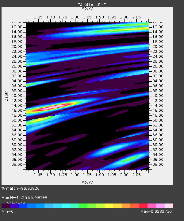
K41A Shullsburg, WI, USA - Earthquake Result Viewer

Earthquake location: Off East Coast Of Honshu, Japan
Earthquake latitude/longitude: 36.8/143.8
Earthquake time(UTC): 2011/08/17 (229) 11:44:08 GMT
Earthquake Depth: 9.0 km
Earthquake Magnitude: 6.1 MB, 5.8 MS, 6.2 MW, 6.1 MW
Earthquake Catalog/Contributor: WHDF/NEIC
Network: TA USArray Transportable Network (new EarthScope stations)
Station: K41A Shullsburg, WI, USA
Lat/Lon: 42.61 N/90.30 W
Elevation: 298 m
Distance: 86.9 deg
Az: 36.778 deg
Baz: 319.366 deg
Ray Param: 0.043718424
Estimated Moho Depth: 44.25 km
Estimated Crust Vp/Vs: 1.72
Assumed Crust Vp: 6.53 km/s
Estimated Crust Vs: 3.802 km/s
Estimated Crust Poisson's Ratio: 0.24
Radial Match: 96.33826 %
Radial Bump: 400
Transverse Match: 89.56368 %
Transverse Bump: 400
SOD ConfigId: 410809
Insert Time: 2012-01-06 07:23:46.527 +0000
GWidth: 2.5
Max Bumps: 400
Tol: 0.001

Signal To Noise

ChannelStoNSTALTA
TA:K41A: :BHZ:20110817T11:56:21.875005Z35.6429062.7533088E-67.724703E-8
TA:K41A: :BHN:20110817T11:56:21.875005Z17.2073678.027852E-74.665358E-8
TA:K41A: :BHE:20110817T11:56:21.875005Z14.5024448.0398377E-75.543781E-8
Arrivals
Ps5.0 SECOND
PpPs18 SECOND
PsPs/PpSs23 SECOND