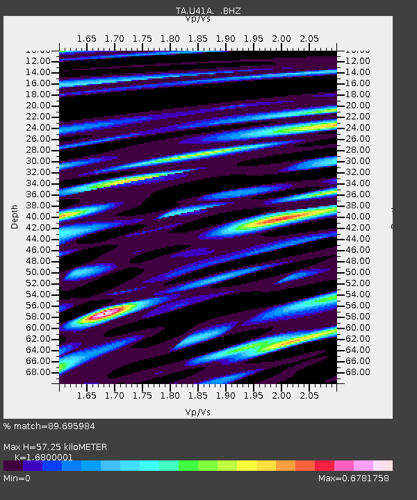
U41A Viola, AR, USA - Earthquake Result Viewer

Earthquake location: Off East Coast Of Honshu, Japan
Earthquake latitude/longitude: 36.8/143.8
Earthquake time(UTC): 2011/08/17 (229) 11:44:08 GMT
Earthquake Depth: 9.0 km
Earthquake Magnitude: 6.1 MB, 5.8 MS, 6.2 MW, 6.1 MW
Earthquake Catalog/Contributor: WHDF/NEIC
Network: TA USArray Transportable Network (new EarthScope stations)
Station: U41A Viola, AR, USA
Lat/Lon: 36.34 N/91.92 W
Elevation: 300 m
Distance: 90.8 deg
Az: 41.832 deg
Baz: 318.443 deg
Ray Param: 0.041648377
Estimated Moho Depth: 57.25 km
Estimated Crust Vp/Vs: 1.68
Assumed Crust Vp: 6.53 km/s
Estimated Crust Vs: 3.887 km/s
Estimated Crust Poisson's Ratio: 0.23
Radial Match: 89.695984 %
Radial Bump: 400
Transverse Match: 78.776985 %
Transverse Bump: 400
SOD ConfigId: 410809
Insert Time: 2012-01-06 07:23:55.483 +0000
GWidth: 2.5
Max Bumps: 400
Tol: 0.001

Signal To Noise

ChannelStoNSTALTA
TA:U41A: :BHZ:20110817T11:56:40.22498Z21.7079321.5394796E-67.091784E-8
TA:U41A: :BHN:20110817T11:56:40.22498Z10.3161545.9269775E-75.7453363E-8
TA:U41A: :BHE:20110817T11:56:40.22498Z7.78143454.26271E-75.4780514E-8
Arrivals
Ps6.1 SECOND
PpPs23 SECOND
PsPs/PpSs29 SECOND