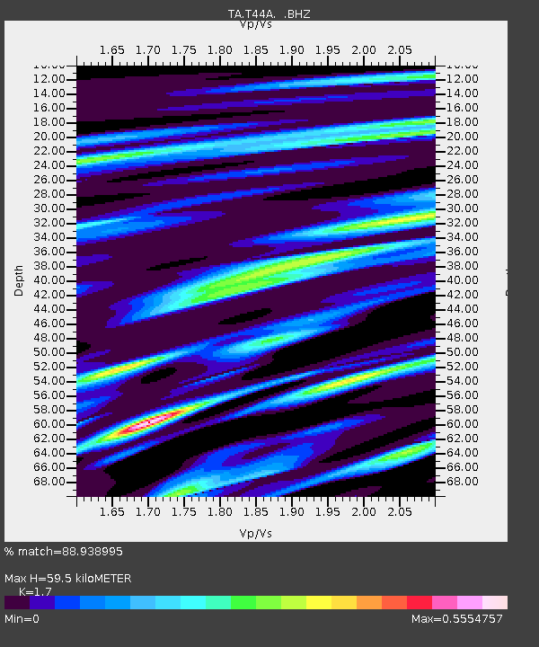
T44A Benton, MO, USA - Earthquake Result Viewer
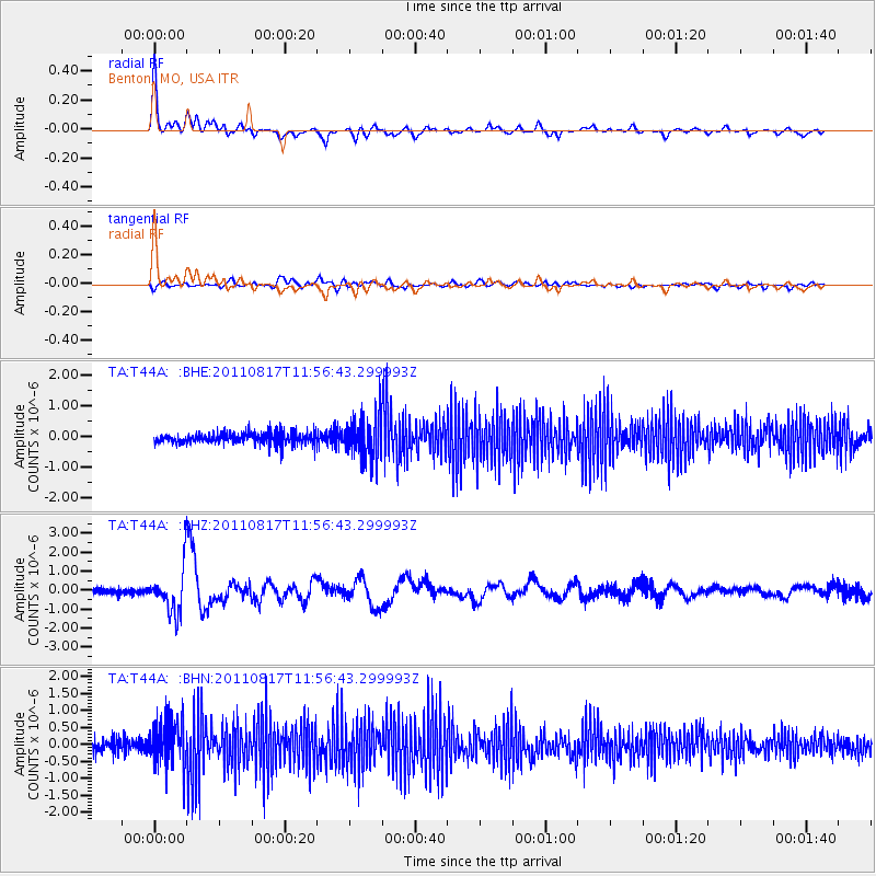
Earthquake location: Off East Coast Of Honshu, Japan
Earthquake latitude/longitude: 36.8/143.8
Earthquake time(UTC): 2011/08/17 (229) 11:44:08 GMT
Earthquake Depth: 9.0 km
Earthquake Magnitude: 6.1 MB, 5.8 MS, 6.2 MW, 6.1 MW
Earthquake Catalog/Contributor: WHDF/NEIC
Network: TA USArray Transportable Network (new EarthScope stations)
Station: T44A Benton, MO, USA
Lat/Lon: 37.09 N/89.59 W
Elevation: 133 m
Distance: 91.5 deg
Az: 39.931 deg
Baz: 319.868 deg
Ray Param: 0.041600965
Estimated Moho Depth: 59.5 km
Estimated Crust Vp/Vs: 1.70
Assumed Crust Vp: 6.444 km/s
Estimated Crust Vs: 3.791 km/s
Estimated Crust Poisson's Ratio: 0.24
Radial Match: 88.938995 %
Radial Bump: 400
Transverse Match: 70.59468 %
Transverse Bump: 400
SOD ConfigId: 410809
Insert Time: 2012-01-06 07:24:00.132 +0000
GWidth: 2.5
Max Bumps: 400
Tol: 0.001

Signal To Noise

ChannelStoNSTALTA
TA:T44A: :BHZ:20110817T11:56:43.299993Z7.64295051.1572234E-61.5141057E-7
TA:T44A: :BHN:20110817T11:56:43.299993Z4.01781656.7080555E-71.6695772E-7
TA:T44A: :BHE:20110817T11:56:43.299993Z3.7992086.922469E-71.8220821E-7
Arrivals
Ps6.6 SECOND
PpPs24 SECOND
PsPs/PpSs31 SECOND