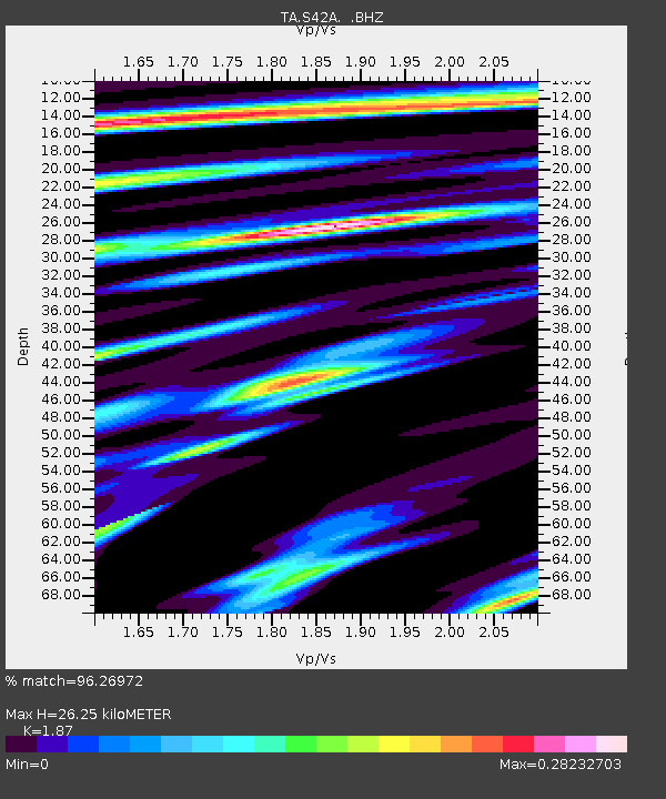
S42A Caledonia, MO, USA - Earthquake Result Viewer

Earthquake location: Off East Coast Of Honshu, Japan
Earthquake latitude/longitude: 36.8/143.8
Earthquake time(UTC): 2011/08/17 (229) 11:44:08 GMT
Earthquake Depth: 9.0 km
Earthquake Magnitude: 6.1 MB, 5.8 MS, 6.2 MW, 6.1 MW
Earthquake Catalog/Contributor: WHDF/NEIC
Network: TA USArray Transportable Network (new EarthScope stations)
Station: S42A Caledonia, MO, USA
Lat/Lon: 37.77 N/90.79 W
Elevation: 315 m
Distance: 90.3 deg
Az: 40.217 deg
Baz: 319.135 deg
Ray Param: 0.041682404
Estimated Moho Depth: 26.25 km
Estimated Crust Vp/Vs: 1.87
Assumed Crust Vp: 6.53 km/s
Estimated Crust Vs: 3.492 km/s
Estimated Crust Poisson's Ratio: 0.30
Radial Match: 96.26972 %
Radial Bump: 359
Transverse Match: 79.872604 %
Transverse Bump: 400
SOD ConfigId: 410809
Insert Time: 2012-01-06 07:24:09.194 +0000
GWidth: 2.5
Max Bumps: 400
Tol: 0.001

Signal To Noise

ChannelStoNSTALTA
TA:S42A: :BHZ:20110817T11:56:38.000005Z30.7871482.1399055E-66.9506456E-8
TA:S42A: :BHN:20110817T11:56:38.000005Z4.6985724.24414E-79.032829E-8
TA:S42A: :BHE:20110817T11:56:38.000005Z9.948054.2923142E-74.3147292E-8
Arrivals
Ps3.6 SECOND
PpPs11 SECOND
PsPs/PpSs15 SECOND