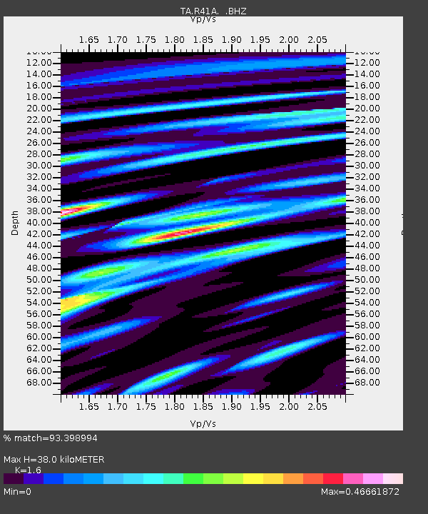
R41A Rosebud, MO, USA - Earthquake Result Viewer

Earthquake location: Off East Coast Of Honshu, Japan
Earthquake latitude/longitude: 36.8/143.8
Earthquake time(UTC): 2011/08/17 (229) 11:44:08 GMT
Earthquake Depth: 9.0 km
Earthquake Magnitude: 6.1 MB, 5.8 MS, 6.2 MW, 6.1 MW
Earthquake Catalog/Contributor: WHDF/NEIC
Network: TA USArray Transportable Network (new EarthScope stations)
Station: R41A Rosebud, MO, USA
Lat/Lon: 38.30 N/91.38 W
Elevation: 257 m
Distance: 89.6 deg
Az: 40.219 deg
Baz: 318.776 deg
Ray Param: 0.041732393
Estimated Moho Depth: 38.0 km
Estimated Crust Vp/Vs: 1.60
Assumed Crust Vp: 6.498 km/s
Estimated Crust Vs: 4.061 km/s
Estimated Crust Poisson's Ratio: 0.18
Radial Match: 93.398994 %
Radial Bump: 394
Transverse Match: 81.02252 %
Transverse Bump: 400
SOD ConfigId: 410809
Insert Time: 2012-01-06 07:24:24.395 +0000
GWidth: 2.5
Max Bumps: 400
Tol: 0.001

Signal To Noise

ChannelStoNSTALTA
TA:R41A: :BHZ:20110817T11:56:34.775029Z32.7807462.332115E-67.114283E-8
TA:R41A: :BHN:20110817T11:56:34.775029Z9.6360096.0272106E-76.254883E-8
TA:R41A: :BHE:20110817T11:56:34.775029Z5.52017974.7982786E-78.6922505E-8
Arrivals
Ps3.6 SECOND
PpPs15 SECOND
PsPs/PpSs18 SECOND