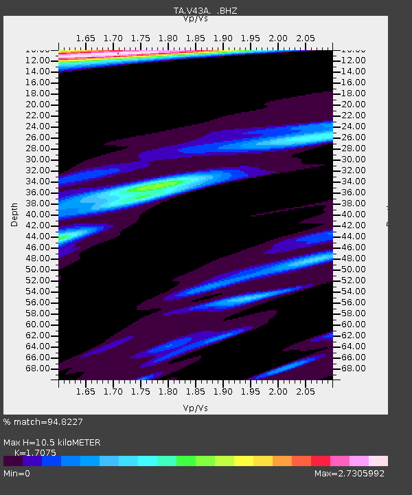
V43A Jonesboro, AR, USA - Earthquake Result Viewer
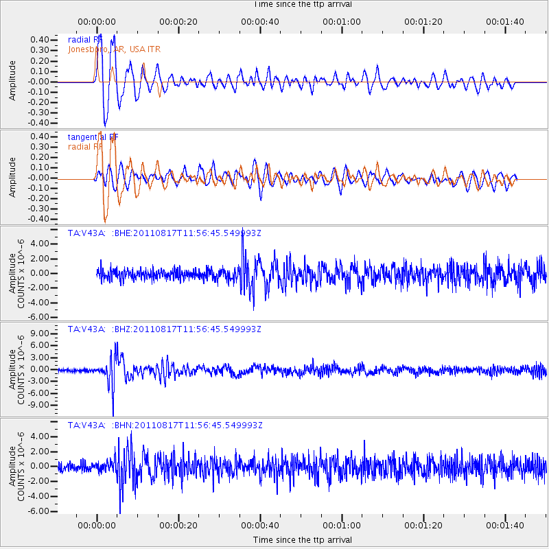
Earthquake location: Off East Coast Of Honshu, Japan
Earthquake latitude/longitude: 36.8/143.8
Earthquake time(UTC): 2011/08/17 (229) 11:44:08 GMT
Earthquake Depth: 9.0 km
Earthquake Magnitude: 6.1 MB, 5.8 MS, 6.2 MW, 6.1 MW
Earthquake Catalog/Contributor: WHDF/NEIC
Network: TA USArray Transportable Network (new EarthScope stations)
Station: V43A Jonesboro, AR, USA
Lat/Lon: 35.79 N/90.54 W
Elevation: 74 m
Distance: 91.9 deg
Az: 41.359 deg
Baz: 319.261 deg
Ray Param: 0.041533414
Estimated Moho Depth: 10.5 km
Estimated Crust Vp/Vs: 1.71
Assumed Crust Vp: 6.273 km/s
Estimated Crust Vs: 3.674 km/s
Estimated Crust Poisson's Ratio: 0.24
Radial Match: 94.8227 %
Radial Bump: 400
Transverse Match: 79.42615 %
Transverse Bump: 400
SOD ConfigId: 410809
Insert Time: 2012-01-06 07:24:56.493 +0000
GWidth: 2.5
Max Bumps: 400
Tol: 0.001

Signal To Noise

ChannelStoNSTALTA
TA:V43A: :BHZ:20110817T11:56:45.549993Z9.7237273.4016903E-63.4983398E-7
TA:V43A: :BHN:20110817T11:56:45.549993Z1.27396.737884E-75.289178E-7
TA:V43A: :BHE:20110817T11:56:45.549993Z1.20684596.7455693E-75.589421E-7
Arrivals
Ps1.2 SECOND
PpPs4.4 SECOND
PsPs/PpSs5.6 SECOND