I41A Arkdale, WI, USA - Earthquake Result Viewer
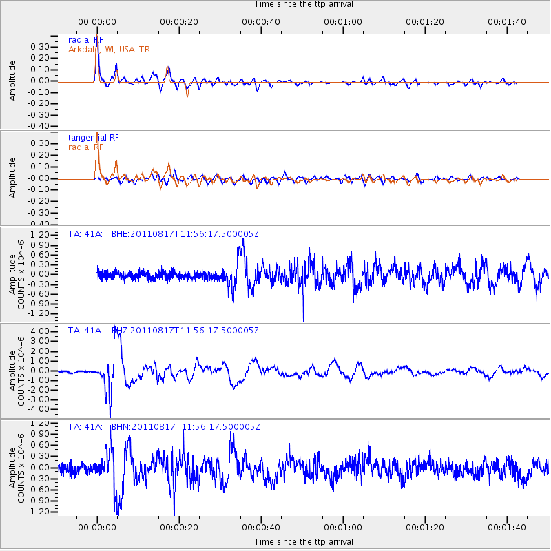
Earthquake location: Off East Coast Of Honshu, Japan
Earthquake latitude/longitude: 36.8/143.8
Earthquake time(UTC): 2011/08/17 (229) 11:44:08 GMT
Earthquake Depth: 9.0 km
Earthquake Magnitude: 6.1 MB, 5.8 MS, 6.2 MW, 6.1 MW
Earthquake Catalog/Contributor: WHDF/NEIC
Network: TA USArray Transportable Network (new EarthScope stations)
Station: I41A Arkdale, WI, USA
Lat/Lon: 44.06 N/89.87 W
Elevation: 289 m
Distance: 86.0 deg
Az: 35.592 deg
Baz: 319.59 deg
Ray Param: 0.044364523
Estimated Moho Depth: 43.0 km
Estimated Crust Vp/Vs: 1.68
Assumed Crust Vp: 6.41 km/s
Estimated Crust Vs: 3.81 km/s
Estimated Crust Poisson's Ratio: 0.23
Radial Match: 94.96328 %
Radial Bump: 400
Transverse Match: 84.21507 %
Transverse Bump: 400
SOD ConfigId: 410809
Insert Time: 2012-01-06 07:26:20.978 +0000
GWidth: 2.5
Max Bumps: 400
Tol: 0.001

Signal To Noise

ChannelStoNSTALTA
TA:I41A: :BHZ:20110817T11:56:17.500005Z31.0099742.114936E-66.820179E-8
TA:I41A: :BHN:20110817T11:56:17.500005Z4.09739164.7195138E-71.15183376E-7
TA:I41A: :BHE:20110817T11:56:17.500005Z3.92956453.9407624E-71.00284964E-7
Arrivals
Ps4.7 SECOND
PpPs18 SECOND
PsPs/PpSs22 SECOND