You are here: Home > Network List > TA - USArray Transportable Network (new EarthScope stations) Stations List
> Station G59A Clarenceville, QC, USA > Earthquake Result Viewer
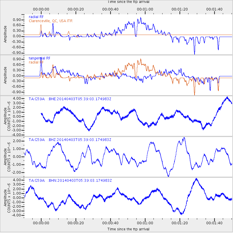
G59A Clarenceville, QC, USA - Earthquake Result Viewer
*The percent match for this event was below the threshold and hence no stack was calculated.
| Earthquake location: |
Near Coast Of Northern Chile |
| Earthquake latitude/longitude: |
-20.8/-70.6 |
| Earthquake time(UTC): |
2014/04/03 (093) 05:28:50 GMT |
| Earthquake Depth: |
11 km |
| Earthquake Magnitude: |
5.6 mb |
| Earthquake Catalog/Contributor: |
ISC/ISC |
|
| Network: |
TA USArray Transportable Network (new EarthScope stations) |
| Station: |
G59A Clarenceville, QC, USA |
| Lat/Lon: |
45.08 N/73.18 W |
| Elevation: |
36 m |
|
| Distance: |
65.6 deg |
| Az: |
357.975 deg |
| Baz: |
177.326 deg |
| Ray Param: |
$rayparam |
*The percent match for this event was below the threshold and hence was not used in the summary stack. |
|
| Radial Match: |
55.7637 % |
| Radial Bump: |
400 |
| Transverse Match: |
67.38195 % |
| Transverse Bump: |
400 |
| SOD ConfigId: |
3390531 |
| Insert Time: |
2019-04-11 02:52:27.144 +0000 |
| GWidth: |
2.5 |
| Max Bumps: |
400 |
| Tol: |
0.001 |
|
Signal To Noise
| Channel | StoN | STA | LTA |
| TA:G59A: :BHZ:20140403T05:39:03.174983Z | 0.88546365 | 1.1699901E-6 | 1.3213306E-6 |
| TA:G59A: :BHN:20140403T05:39:03.174983Z | 0.9852072 | 4.043243E-6 | 4.1039516E-6 |
| TA:G59A: :BHE:20140403T05:39:03.174983Z | 1.2559402 | 1.3104186E-6 | 1.0433766E-6 |
| Arrivals |
| Ps | |
| PpPs | |
| PsPs/PpSs | |


