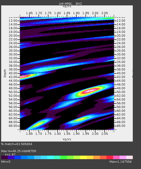
MRBL Marblemount, WA, USA - Earthquake Result Viewer
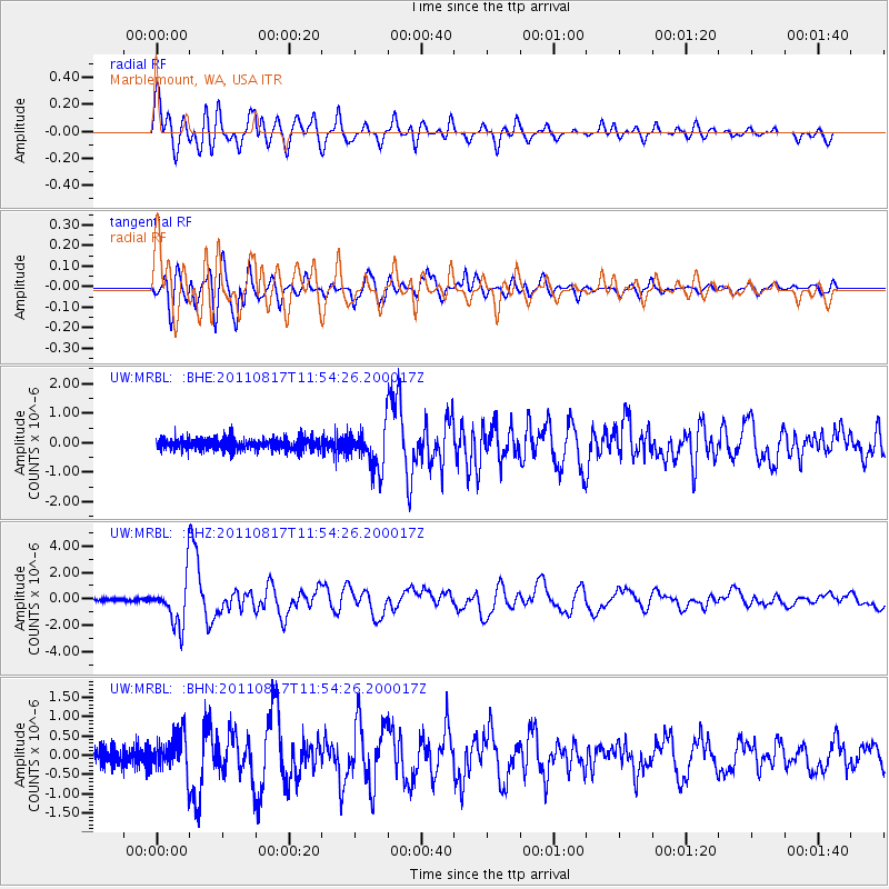
Earthquake location: Off East Coast Of Honshu, Japan
Earthquake latitude/longitude: 36.8/143.8
Earthquake time(UTC): 2011/08/17 (229) 11:44:08 GMT
Earthquake Depth: 9.0 km
Earthquake Magnitude: 6.1 MB, 5.8 MS, 6.2 MW, 6.1 MW
Earthquake Catalog/Contributor: WHDF/NEIC
Network: UW Pacific Northwest Regional Seismic Network
Station: MRBL Marblemount, WA, USA
Lat/Lon: 48.52 N/121.48 W
Elevation: 75 m
Distance: 66.4 deg
Az: 46.327 deg
Baz: 299.124 deg
Ray Param: 0.057669163
Estimated Moho Depth: 49.25 km
Estimated Crust Vp/Vs: 1.97
Assumed Crust Vp: 6.566 km/s
Estimated Crust Vs: 3.333 km/s
Estimated Crust Poisson's Ratio: 0.33
Radial Match: 83.585884 %
Radial Bump: 400
Transverse Match: 88.3478 %
Transverse Bump: 400
SOD ConfigId: 410809
Insert Time: 2012-01-06 07:28:43.474 +0000
GWidth: 2.5
Max Bumps: 400
Tol: 0.001

Signal To Noise

ChannelStoNSTALTA
UW:MRBL: :BHZ:20110817T11:54:26.200017Z22.8509431.7419437E-67.623071E-8
UW:MRBL: :BHN:20110817T11:54:26.200017Z2.50399924.832074E-71.9297426E-7
UW:MRBL: :BHE:20110817T11:54:26.200017Z3.46534446.932253E-72.0004514E-7
Arrivals
Ps7.6 SECOND
PpPs21 SECOND
PsPs/PpSs29 SECOND