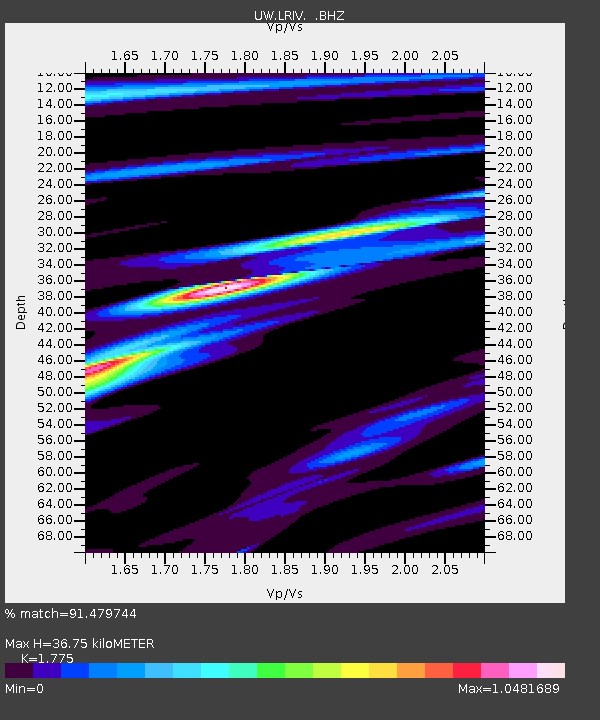
LRIV Port Angeles, WA, USA - Earthquake Result Viewer

Earthquake location: Off East Coast Of Honshu, Japan
Earthquake latitude/longitude: 36.8/143.8
Earthquake time(UTC): 2011/08/17 (229) 11:44:08 GMT
Earthquake Depth: 9.0 km
Earthquake Magnitude: 6.1 MB, 5.8 MS, 6.2 MW, 6.1 MW
Earthquake Catalog/Contributor: WHDF/NEIC
Network: UW Pacific Northwest Regional Seismic Network
Station: LRIV Port Angeles, WA, USA
Lat/Lon: 48.06 N/123.50 W
Elevation: 294 m
Distance: 65.4 deg
Az: 47.478 deg
Baz: 298.091 deg
Ray Param: 0.05830081
Estimated Moho Depth: 36.75 km
Estimated Crust Vp/Vs: 1.77
Assumed Crust Vp: 6.566 km/s
Estimated Crust Vs: 3.699 km/s
Estimated Crust Poisson's Ratio: 0.27
Radial Match: 91.479744 %
Radial Bump: 400
Transverse Match: 91.071884 %
Transverse Bump: 400
SOD ConfigId: 410809
Insert Time: 2012-01-06 07:29:28.174 +0000
GWidth: 2.5
Max Bumps: 400
Tol: 0.001

Signal To Noise

ChannelStoNSTALTA
UW:LRIV: :BHZ:20110817T11:54:20.01502Z22.5833511.4382173E-66.368485E-8
UW:LRIV: :BHN:20110817T11:54:20.01502Z4.63576133.998577E-78.625502E-8
UW:LRIV: :BHE:20110817T11:54:20.01502Z4.73982435.158462E-71.0883234E-7
Arrivals
Ps4.5 SECOND
PpPs15 SECOND
PsPs/PpSs19 SECOND