You are here: Home > Network List > TA - USArray Transportable Network (new EarthScope stations) Stations List
> Station O48A Farmland, IN, USA > Earthquake Result Viewer
O48A Farmland, IN, USA - Earthquake Result Viewer

| Earthquake location: |
Near Coast Of Northern Chile |
| Earthquake latitude/longitude: |
-20.8/-70.6 |
| Earthquake time(UTC): |
2014/04/03 (093) 05:28:50 GMT |
| Earthquake Depth: |
11 km |
| Earthquake Magnitude: |
5.6 mb |
| Earthquake Catalog/Contributor: |
ISC/ISC |
|
| Network: |
TA USArray Transportable Network (new EarthScope stations) |
| Station: |
O48A Farmland, IN, USA |
| Lat/Lon: |
40.26 N/85.16 W |
| Elevation: |
300 m |
|
| Distance: |
62.3 deg |
| Az: |
347.431 deg |
| Baz: |
164.574 deg |
| Ray Param: |
0.0603338 |
| Estimated Moho Depth: |
32.5 km |
| Estimated Crust Vp/Vs: |
1.60 |
| Assumed Crust Vp: |
6.498 km/s |
| Estimated Crust Vs: |
4.061 km/s |
| Estimated Crust Poisson's Ratio: |
0.18 |
|
| Radial Match: |
83.13153 % |
| Radial Bump: |
400 |
| Transverse Match: |
81.88992 % |
| Transverse Bump: |
400 |
| SOD ConfigId: |
3390531 |
| Insert Time: |
2019-04-11 02:52:59.522 +0000 |
| GWidth: |
2.5 |
| Max Bumps: |
400 |
| Tol: |
0.001 |
|
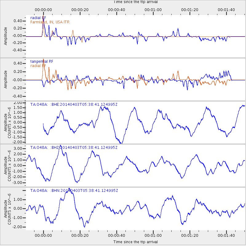
Signal To Noise
| Channel | StoN | STA | LTA |
| TA:O48A: :BHZ:20140403T05:38:41.124995Z | 3.3228006 | 2.3724685E-6 | 7.1399666E-7 |
| TA:O48A: :BHN:20140403T05:38:41.124995Z | 1.6719195 | 1.0022981E-6 | 5.994894E-7 |
| TA:O48A: :BHE:20140403T05:38:41.124995Z | 2.5454957 | 1.478E-6 | 5.806334E-7 |
| Arrivals |
| Ps | 3.2 SECOND |
| PpPs | 12 SECOND |
| PsPs/PpSs | 16 SECOND |


