You are here: Home > Network List > TA - USArray Transportable Network (new EarthScope stations) Stations List
> Station S56A Natural Bridge, VA, USA > Earthquake Result Viewer
S56A Natural Bridge, VA, USA - Earthquake Result Viewer
| Earthquake location: |
Near Coast Of Northern Chile |
| Earthquake latitude/longitude: |
-20.8/-70.6 |
| Earthquake time(UTC): |
2014/04/03 (093) 05:28:50 GMT |
| Earthquake Depth: |
11 km |
| Earthquake Magnitude: |
5.6 mb |
| Earthquake Catalog/Contributor: |
ISC/ISC |
|
| Network: |
TA USArray Transportable Network (new EarthScope stations) |
| Station: |
S56A Natural Bridge, VA, USA |
| Lat/Lon: |
37.68 N/79.57 W |
| Elevation: |
449 m |
|
| Distance: |
58.8 deg |
| Az: |
351.667 deg |
| Baz: |
170.162 deg |
| Ray Param: |
0.06260224 |
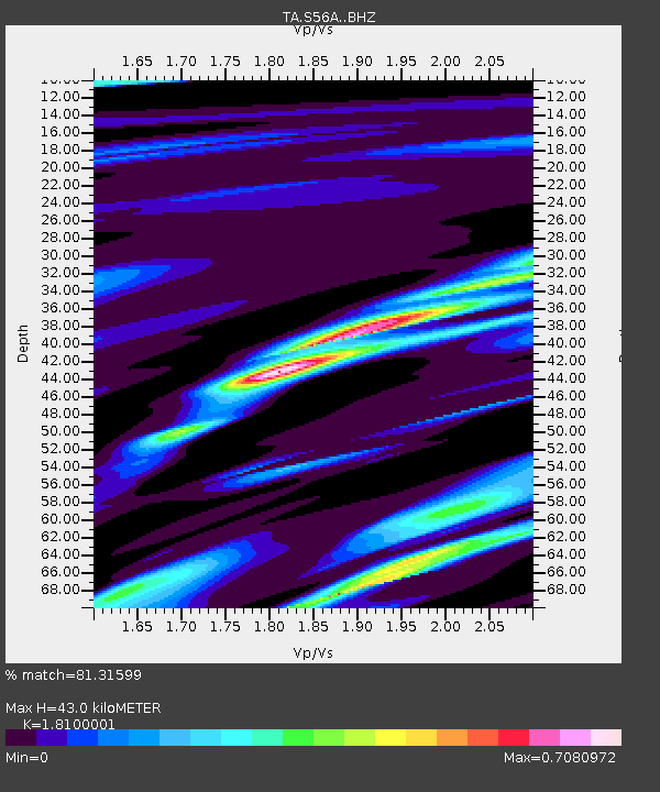
| Estimated Moho Depth: |
43.0 km |
| Estimated Crust Vp/Vs: |
1.81 |
| Assumed Crust Vp: |
6.419 km/s |
| Estimated Crust Vs: |
3.547 km/s |
| Estimated Crust Poisson's Ratio: |
0.28 |
|
| Radial Match: |
81.31599 % |
| Radial Bump: |
400 |
| Transverse Match: |
71.15846 % |
| Transverse Bump: |
400 |
| SOD ConfigId: |
3390531 |
| Insert Time: |
2019-04-11 02:53:12.372 +0000 |
| GWidth: |
2.5 |
| Max Bumps: |
400 |
| Tol: |
0.001 |
|

Signal To Noise
| Channel | StoN | STA | LTA |
| TA:S56A: :BHZ:20140403T05:38:17.499995Z | 3.1209474 | 1.5808696E-6 | 5.065352E-7 |
| TA:S56A: :BHN:20140403T05:38:17.499995Z | 0.32002404 | 2.366901E-7 | 7.39601E-7 |
| TA:S56A: :BHE:20140403T05:38:17.499995Z | 1.0966203 | 1.2709902E-6 | 1.1590066E-6 |
| Arrivals |
| Ps | 5.7 SECOND |
| PpPs | 18 SECOND |
| PsPs/PpSs | 24 SECOND |


