You are here: Home > Network List > AU - Australian Seismological Centre Stations List
> Station QIS Mount Isa, Queensland > Earthquake Result Viewer
QIS Mount Isa, Queensland - Earthquake Result Viewer
| Earthquake location: |
Fiji Islands Region |
| Earthquake latitude/longitude: |
-16.5/-177.0 |
| Earthquake time(UTC): |
2011/08/19 (231) 03:54:26 GMT |
| Earthquake Depth: |
408 km |
| Earthquake Magnitude: |
5.5 MB, 6.2 MW, 6.2 MW |
| Earthquake Catalog/Contributor: |
WHDF/NEIC |
|
| Network: |
AU Australian Seismological Centre |
| Station: |
QIS Mount Isa, Queensland |
| Lat/Lon: |
20.56 S/139.61 E |
| Elevation: |
450 m |
|
| Distance: |
41.2 deg |
| Az: |
257.528 deg |
| Baz: |
91.87 deg |
| Ray Param: |
0.07207206 |
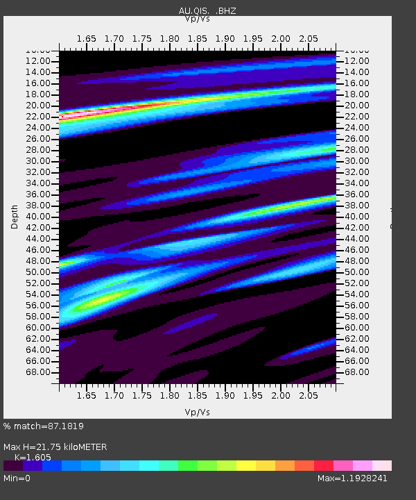
| Estimated Moho Depth: |
21.75 km |
| Estimated Crust Vp/Vs: |
1.61 |
| Assumed Crust Vp: |
6.577 km/s |
| Estimated Crust Vs: |
4.098 km/s |
| Estimated Crust Poisson's Ratio: |
0.18 |
|
| Radial Match: |
87.1819 % |
| Radial Bump: |
245 |
| Transverse Match: |
68.74293 % |
| Transverse Bump: |
400 |
| SOD ConfigId: |
410809 |
| Insert Time: |
2012-01-06 07:35:47.365 +0000 |
| GWidth: |
2.5 |
| Max Bumps: |
400 |
| Tol: |
0.001 |
|

Signal To Noise
| Channel | StoN | STA | LTA |
| AU:QIS: :BHZ:20110819T04:01:03.670015Z | 9.403127 | 1.6693937E-6 | 1.7753604E-7 |
| AU:QIS: :BHN:20110819T04:01:03.670015Z | 4.0417223 | 4.921488E-7 | 1.2176709E-7 |
| AU:QIS: :BHE:20110819T04:01:03.670015Z | 7.3140807 | 1.0597439E-6 | 1.4489093E-7 |
| Arrivals |
| Ps | 2.2 SECOND |
| PpPs | 8.0 SECOND |
| PsPs/PpSs | 10 SECOND |


