You are here: Home > Network List > AZ - ANZA Regional Network Stations List
> Station SMER AZ.SMER > Earthquake Result Viewer
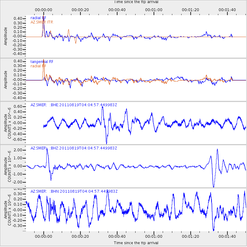
SMER AZ.SMER - Earthquake Result Viewer
*The percent match for this event was below the threshold and hence no stack was calculated.
| Earthquake location: |
Fiji Islands Region |
| Earthquake latitude/longitude: |
-16.5/-177.0 |
| Earthquake time(UTC): |
2011/08/19 (231) 03:54:26 GMT |
| Earthquake Depth: |
408 km |
| Earthquake Magnitude: |
5.5 MB, 6.2 MW, 6.2 MW |
| Earthquake Catalog/Contributor: |
WHDF/NEIC |
|
| Network: |
AZ ANZA Regional Network |
| Station: |
SMER AZ.SMER |
| Lat/Lon: |
33.46 N/117.17 W |
| Elevation: |
355 m |
|
| Distance: |
75.6 deg |
| Az: |
48.25 deg |
| Baz: |
238.874 deg |
| Ray Param: |
$rayparam |
*The percent match for this event was below the threshold and hence was not used in the summary stack. |
|
| Radial Match: |
70.88478 % |
| Radial Bump: |
400 |
| Transverse Match: |
68.96432 % |
| Transverse Bump: |
400 |
| SOD ConfigId: |
410809 |
| Insert Time: |
2012-01-06 07:39:08.495 +0000 |
| GWidth: |
2.5 |
| Max Bumps: |
400 |
| Tol: |
0.001 |
|
Signal To Noise
| Channel | StoN | STA | LTA |
| AZ:SMER: :BHZ:20110819T04:04:57.449983Z | 6.7511597 | 9.804304E-7 | 1.4522399E-7 |
| AZ:SMER: :BHN:20110819T04:04:57.449983Z | 1.0083005 | 1.3230114E-7 | 1.31212E-7 |
| AZ:SMER: :BHE:20110819T04:04:57.449983Z | 3.1202834 | 3.4063802E-7 | 1.09168944E-7 |
| Arrivals |
| Ps | |
| PpPs | |
| PsPs/PpSs | |


